No higher resolution available.
Chennai.png (219 × 164 pixels, file size: 13 KB, MIME type: image/png)
| This is a file from the Wikimedia Commons. Information from its description page there is shown below. Commons is a freely licensed media file repository. You can help. |
| Description |
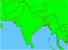
English: This is an incorrect representation of the Republic of India. For a proper geographically correct version of the Republic of India click here: http://www.worldatlas.com/webimage/countrys/asia/lgcolor/incolor.htm This map is an objective illustration showing even the "disputed" region of Kashmir which forms an integral part of India. This map was generated using all open-source software on an open-source unix operating system. The map itself and the marking of the co-ordinates were done using GMT software, and conversion to png format was done using ImageMagick. Please notice this is different form using graphics arts software tools to create maps or other pictures. In fact, this map was created by issuing only 3 command lines from a unix shell, without even using any GUI -- and GUI was used only to view the final picture before uploading it. GMT is a geographic and cartographic set of tools, with extensive capabilities and options. |
| Date | |
| Source | Own work |
| Author | Unknown author |

|
Permission is granted to copy, distribute and/or modify this document under the terms of the GNU Free Documentation License, Version 1.2 or any later version published by the Free Software Foundation; with no Invariant Sections, no Front-Cover Texts, and no Back-Cover Texts. A copy of the license is included in the section entitled GNU Free Documentation License. |
| This file is licensed under the Creative Commons Attribution-Share Alike 3.0 Unported license. | ||
| ||
| This licensing tag was added to this file as part of the GFDL licensing update. |
File history
Click on a date/time to view the file as it appeared at that time.
| Date/Time | Thumbnail | Dimensions | User | Comment | |
|---|---|---|---|---|---|
| current | 13:51, 6 January 2005 | | 219 × 164 (13 KB) | Sebastian Wallroth | This is an incorrect representation of the Republic of India. For a proper geographically correct version of the Republic of India click here: http://www.worldatlas.com/webimage/countrys/asia/lgcolor/incolor.htm This map is an objective illustration showi |
File usage
No pages on the English Wikipedia use this file (pages on other projects are not listed).
Global file usage
The following other wikis use this file: