No higher resolution available.
Cd-map_small.png (327 × 505 pixels, file size: 23 KB, MIME type: image/png)
| This is a file from the Wikimedia Commons. Information from its description page there is shown below. Commons is a freely licensed media file repository. You can help. |
Summary
| Description |
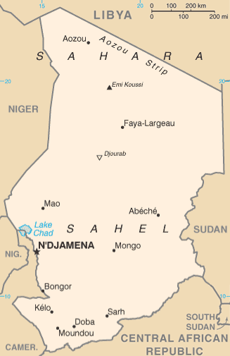
English: Cropped version of Chad map from CIA World Factbook (July 2011 version showing South Sudan). Based on File:Cd-map.png (331 × 716 pixels). |
| Date | Source image: 13 July 2011 |
| Source |
CIA World Factbook |
| Author | United States Central Intelligence Agency |
| Other versions |
|

Licensing
This image is in the public domain because it contains materials that originally came from the United States Central Intelligence Agency's World Factbook.
|
 |
File history
Click on a date/time to view the file as it appeared at that time.
| Date/Time | Thumbnail | Dimensions | User | Comment | |
|---|---|---|---|---|---|
| current | 22:18, 31 August 2012 | | 327 × 505 (23 KB) | Zyxw | Add South Sudan borders and label. Also restored from original image are scale, longitude marks (top), label for Libya, and label for Central African Republic. |
| 18:28, 13 January 2008 |  | 327 × 505 (23 KB) | Grrahnbahr | == Summary == Based on Image:Cd-map.png - A map of Chad, from [https://www.cia.gov/cia/publications/factbook/geos/cd.html]. {{PD-USGov-CIA-WF}} |
File usage
The following pages on the English Wikipedia use this file (pages on other projects are not listed):
Global file usage
The following other wikis use this file:
- Usage on bcl.wikipedia.org
- Usage on ca.wikipedia.org
- Usage on fa.wikipedia.org
- Usage on fr.wikipedia.org
- Usage on hi.wikipedia.org
- Usage on hu.wikipedia.org
- Usage on id.wikipedia.org
- Usage on ilo.wikipedia.org
- Usage on ja.wikipedia.org
- Usage on kn.wikipedia.org
- Usage on ml.wikipedia.org
- Usage on mrj.wikipedia.org
- Usage on ms.wikipedia.org
- Usage on no.wikipedia.org
- Usage on pnb.wikipedia.org
- Usage on si.wikipedia.org
- Usage on sl.wikipedia.org
View more global usage of this file.