Size of this preview: 725 × 600 pixels. Other resolutions: 290 × 240 pixels | 580 × 480 pixels | 928 × 768 pixels | 1,237 × 1,024 pixels | 2,475 × 2,048 pixels | 2,795 × 2,313 pixels.
Original file (2,795 × 2,313 pixels, file size: 5.1 MB, MIME type: image/jpeg)
| This is a file from the Wikimedia Commons. Information from its description page there is shown below. Commons is a freely licensed media file repository. You can help. |
Summary
| Description |
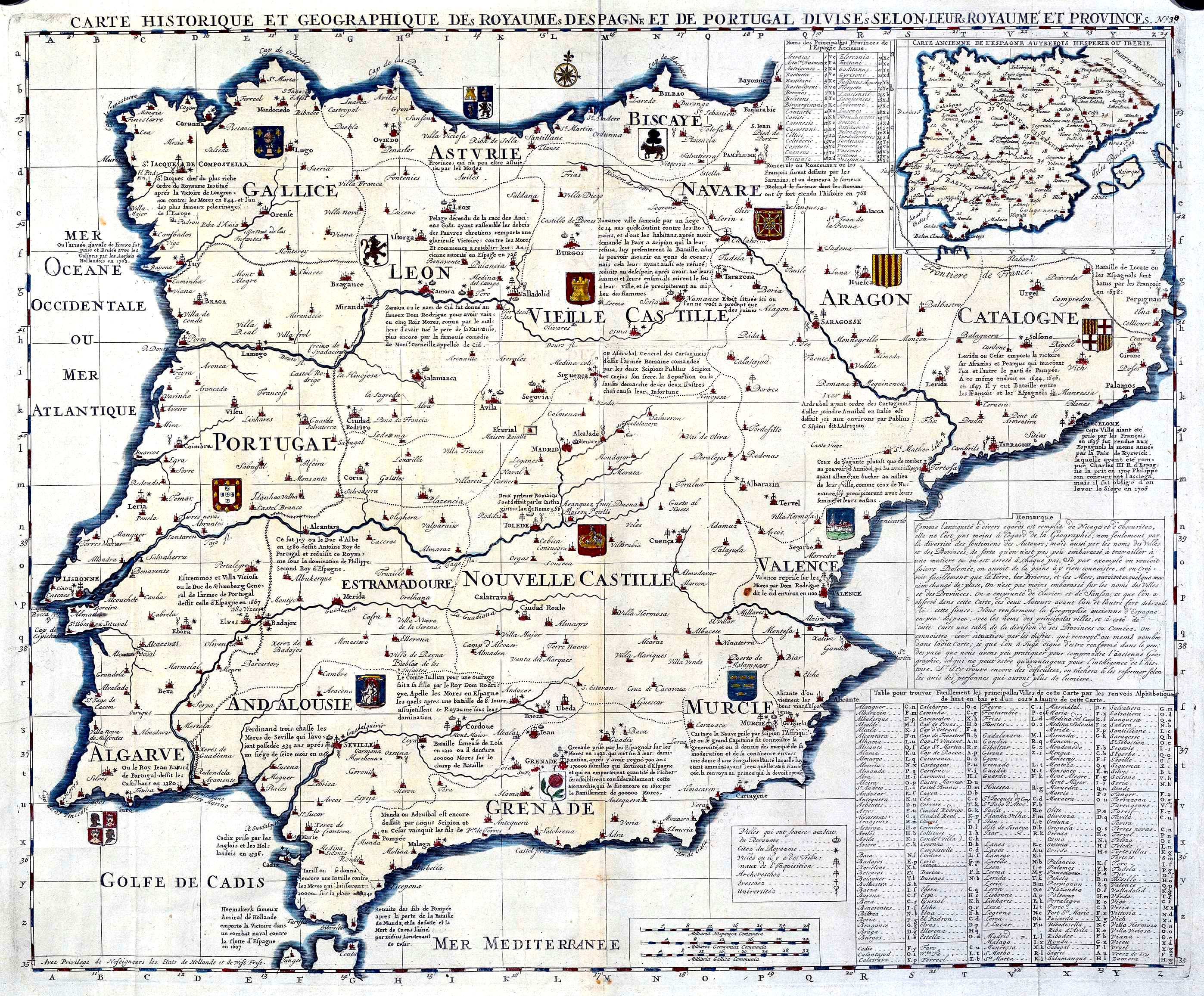
Français : Carte historique et geographique des Royaumes D’Espagne et de Portugal Divises selon leurs Royaume et Provinces : Nº 30. Mapa procedente del "Atlas historique... de H.A. Chatelain", con ediciones desde 1705 a 1739 |
|||||||||||||||||||||||
| Date | between 1705 and 1739 | |||||||||||||||||||||||
| Source | http://www.bne.es/BDH/index.htm http://bibliotecadigitalhispanica.bne.es:80/webclient/DeliveryManager?application=DIGITOOL-3&owner=resourcediscovery&custom_att_2=simple_viewer&pid=90357 | |||||||||||||||||||||||
| Author |
|
|||||||||||||||||||||||

Licensing
|
The author died in 1743, so this work is in the public domain in its country of origin and other countries and areas where the copyright term is the author's life plus 70 years or fewer. This work is in the public domain in the United States because it was published (or registered with the U.S. Copyright Office) before January 1, 1929. | |
| This file has been identified as being free of known restrictions under copyright law, including all related and neighboring rights. | |
File history
Click on a date/time to view the file as it appeared at that time.
| Date/Time | Thumbnail | Dimensions | User | Comment | |
|---|---|---|---|---|---|
| current | 19:47, 9 September 2008 | | 2,795 × 2,313 (5.1 MB) | Escarlati | {{Information |Description={{fr|1=Carte historique et geographique des Royaumes D’Espagne et de Portugal Divises selon leurs Royaume et Provinces : Nº 30. Mapa procedente del "Atlas historique... de H.A. Chatelain", con ediciones desde 1705 a 1739}} |S |
File usage
More than 100 pages use this file. The following list shows the first 100 pages that use this file only. A full list is available.
- 20-N
- Al-Andalus
- Ballestero de monte
- Barcid conquest of Hispania
- Battle of Algeciras (1278)
- Battle of Alhandic
- Battle of Aqbat al-Bakr
- Battle of Bairén
- Battle of Collejares
- Battle of Consuegra
- Battle of Estepona
- Battle of Fraga
- Battle of Guadalacete
- Battle of Iznalloz
- Battle of Jerez
- Battle of La Higueruela
- Battle of Linuesa
- Battle of Los Alporchones
- Battle of Lutos
- Battle of Moclín (1280)
- Battle of Pancorbo (816)
- Battle of Paterna
- Battle of Portopí
- Battle of Río Salado
- Battle of San Esteban de Gormaz (917)
- Battle of Simancas
- Battle of Vega de Pagana
- Battle of the Burbia River
- Battle of the Morcuera
- Battle of the Nervasos Mountains
- Battle of the Puig
- Battle of Écija (1275)
- Bouches-del'Èbre
- Bourbon Reforms
- Catholic Monarchs of Spain
- Conquest of Majorca
- Converso
- Crown rabbi (Iberia)
- Day of Zamora
- Dictatorship of Primo de Rivera
- Economic history of Spain
- Expulsion of the Moriscos
- First Spanish Republic
- First siege of Gibraltar
- Fitna of al-Andalus
- Gallaecia
- Granada War
- Granada chronology
- Gutiérrez–Magee Expedition
- Habsburg Spain
- Hispania
- History of Spain
- History of Spain (1808–1874)
- History of Spain (1975–present)
- Kingdom of Asturias
- List of current Grandees of Spain
- List of grand masters of the Order of Calatrava
- List of years in Spain
- Lordship del Castillo de Carpio
- Lordship of Albarracín
- Modern history of Spain
- Morisco
- Order of Saint Mary of Spain
- Prehistoric Iberia
- Señorío de Sanlúcar
- Siege of Albarracín (1284)
- Siege of Algeciras (1278–1279)
- Siege of Algeciras (1309–1310)
- Siege of Burriana
- Siege of Jaén (1225)
- Siege of Jaén (1230)
- Siege of Jaén (1245–1246)
- Siege of al-Dāmūs
- Social and cultural exchange in al-Andalus
- Spain in the 17th century
- Spain in the Middle Ages
- Spain under Joseph Bonaparte
- Spania
- Spanish Civil War
- Spanish Texas
- Spanish transition to democracy
- Timeline of Barcelona
- Timeline of Bilbao
- Timeline of Cádiz
- Timeline of Córdoba, Spain
- Timeline of Madrid
- Timeline of Murcia
- Timeline of Málaga
- Timeline of Pamplona
- Timeline of Santander, Spain
- Timeline of Seville
- Timeline of Toledo, Spain
- Timeline of Valencia
- Timeline of Valladolid
- Timeline of Zaragoza
- Visigothic Kingdom
- War of Jenkins' Ear
- User:Jone.santiagouri/sandbox/Infobox/Military
- User:Nashrobert18
- User:SolabarrietaM/sandbox/Sandbox/Infobox/Military conflict
View more links to this file.
Global file usage
The following other wikis use this file:
- Usage on ar.wikipedia.org
- بنو نصر
- ملوك الطوائف
- قوط غربيون
- قائمة ملوك إسبانيا
- مملكة القوط الغربيين
- قائمة ملوك البرتغال والغرب
- قائمة ملوك أراغون
- قائمة ولاة الأندلس الأمويين
- قائمة ملوك نافارا
- قائمة ملوك ليون
- قائمة حكام إسبانيا
- قائمة ملوك أستورياس
- قالب:ملوك شبه جزيرة إيبيريا
- قائمة ملوك مايوركا
- إمبراطور كل هيسبانيا
- قائمة ملوك جليقية
- Usage on ast.wikipedia.org
- Usage on es.wikipedia.org
- Usage on ht.wikipedia.org
- Usage on io.wikipedia.org
- Usage on nn.wikipedia.org