
Size of this preview: 688 × 600 pixels. Other resolutions: 275 × 240 pixels | 551 × 480 pixels | 881 × 768 pixels | 1,174 × 1,024 pixels | 2,349 × 2,048 pixels | 9,655 × 8,419 pixels.
Original file (9,655 × 8,419 pixels, file size: 3.66 MB, MIME type: image/png)
| This is a file from the Wikimedia Commons. Information from its description page there is shown below. Commons is a freely licensed media file repository. You can help. |
Summary
| Warning | The original file is very high-resolution. It might not load properly or could cause your browser to freeze when opened at full size. |
|---|
| Description |
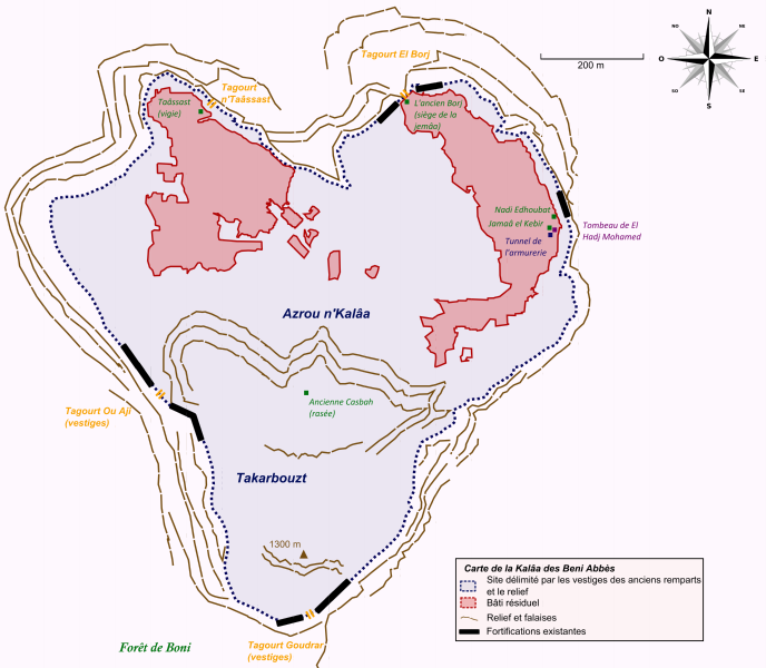
Français : Carte de la Kalaa Beni Abbes (Kabylie, Algérie). English: Map of the Kalaa Beni Abbes (Kabylia, Algeria). |
| Date | |
| Source |
Own work Basé sur : -Carte de l'association Gehimab de Béjaïa. -Google Maps pour la situation et l'orientation du site. -Livre de Youssef Benoudjit, La Kalâa des Beni Abbes au XVIe siècle, Dahlab, 1997. |
| Author | Kabyle20 |
Licensing
I, the copyright holder of this work, hereby publish it under the following license:
This file is licensed under the Creative Commons Attribution-Share Alike 4.0 International license.
- You are free:
- to share – to copy, distribute and transmit the work
- to remix – to adapt the work
- Under the following conditions:
- attribution – You must give appropriate credit, provide a link to the license, and indicate if changes were made. You may do so in any reasonable manner, but not in any way that suggests the licensor endorses you or your use.
- share alike – If you remix, transform, or build upon the material, you must distribute your contributions under the same or compatible license as the original.
File history
Click on a date/time to view the file as it appeared at that time.
| Date/Time | Thumbnail | Dimensions | User | Comment | |
|---|---|---|---|---|---|
| current | 10:10, 31 October 2014 | | 9,655 × 8,419 (3.66 MB) | Monsieur Patillo | typo |
| 10:08, 31 October 2014 |  | 14,495 × 8,914 (3.91 MB) | Monsieur Patillo | Typo | |
| 22:43, 30 October 2014 |  | 11,586 × 10,103 (4.51 MB) | Monsieur Patillo | Point culminant. | |
| 22:19, 30 October 2014 |  | 14,495 × 8,914 (3.87 MB) | Monsieur Patillo | Correction again ! | |
| 21:21, 30 October 2014 |  | 12,873 × 11,225 (4.93 MB) | Monsieur Patillo | Lisibilité | |
| 20:31, 30 October 2014 |  | 22,285 × 17,789 (8.27 MB) | Monsieur Patillo | Correction. Lisibilité. | |
| 19:38, 30 October 2014 |  | 35,656 × 28,463 (14.61 MB) | Monsieur Patillo | Légende + Echelle | |
| 18:48, 30 October 2014 |  | 42,167 × 28,091 (15.09 MB) | Monsieur Patillo | Fond | |
| 18:19, 30 October 2014 |  | 68,181 × 42,322 (26.76 MB) | Monsieur Patillo | Fond | |
| 17:58, 30 October 2014 |  | 46,094 × 41,911 (21.2 MB) | Monsieur Patillo | User created page with UploadWizard |
File usage
The following pages on the English Wikipedia use this file (pages on other projects are not listed):
Global file usage
The following other wikis use this file:
- Usage on fr.wikipedia.org