
Size of this preview: 505 × 599 pixels. Other resolutions: 202 × 240 pixels | 404 × 480 pixels | 858 × 1,018 pixels.
Original file (858 × 1,018 pixels, file size: 42 KB, MIME type: image/png)
| This is a file from the Wikimedia Commons. Information from its description page there is shown below. Commons is a freely licensed media file repository. You can help. |
Summary
| Description |
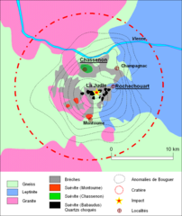
Carte de l'emprise du cratère de la météorite de Rochechouart-Chassenon (France). Réalisation personnelle de Frédéric d'après Kelley & Spray[1] et Pohl & Ernstson[2]
|
| Date | 16 May 2006 (original upload date) |
| Source | Transferred from fr.wikipedia to Commons. |
| Author | The original uploader was Geneamichaud at French Wikipedia. |
| Permission (Reusing this file) |
CC-BY-SA-2.0 FR; CC-BY-SA FR. |
Licensing
This file is licensed under the Creative Commons Attribution-Share Alike 2.0 France license.
- You are free:
- to share – to copy, distribute and transmit the work
- to remix – to adapt the work
- Under the following conditions:
- attribution – You must give appropriate credit, provide a link to the license, and indicate if changes were made. You may do so in any reasonable manner, but not in any way that suggests the licensor endorses you or your use.
- share alike – If you remix, transform, or build upon the material, you must distribute your contributions under the same or compatible license as the original.

Original upload log
The original description page was here. All following user names refer to fr.wikipedia.
- 2006-05-29 12:59 Geneamichaud 858×1018×7 (44473 bytes)
- 2006-05-28 22:30 Geneamichaud 858×1018×8 (45573 bytes) Carte de l'astroblème de Rochechouart-Chassenon. Auteur ~~~~
- 2006-05-16 15:01 Geneamichaud 567×533×8 (155101 bytes) Carte de l'emprise du cratère de la météorite de Rochechouart-Chassenon (France).
Original upload log
| Date/Time | Dimensions | User | Comment |
|---|---|---|---|
| 17 July 2007, 11:35:05 | 858 × 1018 (44473 bytes) | Geneamichaud (talk · contribs) | {{Information |Description=Carte de l'emprise du cratère de la météorite de Rochechouart-Chassenon (France). Réalisation personnelle de [[:fr:Utilisateur:Geneamichaud|Frédéric]] d'après Kelley & Spray<ref> Kelley, Simon P.; Spray, John G. : "A lat |
File history
Click on a date/time to view the file as it appeared at that time.
| Date/Time | Thumbnail | Dimensions | User | Comment | |
|---|---|---|---|---|---|
| current | 08:16, 19 November 2014 | | 858 × 1,018 (42 KB) | GifTagger | Bot: Converting file to superior PNG file. (Source: Carte-rochechouart-chassenon.gif). This GIF was problematic due to non-greyscale color table. |
File usage
The following pages on the English Wikipedia use this file (pages on other projects are not listed):
Global file usage
The following other wikis use this file:
- Usage on de.wikipedia.org
- Usage on fr.wikipedia.org
- Usage on pl.wikipedia.org