No higher resolution available.
Cardigan_Memorial_Hospital_-_geograph.org.uk_-_1691662.jpg (640 × 475 pixels, file size: 113 KB, MIME type: image/jpeg)
| This is a file from the Wikimedia Commons. Information from its description page there is shown below. Commons is a freely licensed media file repository. You can help. |
Summary
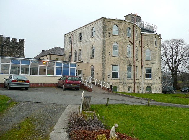
| Description |
English: Cardigan Memorial Hospital This is based on a house of 1788 called The Priory, which replaced a house that was made from the monastic buildings and was the home for a time of the members of Parliament for the borough. The house of 1788-9 was designed by John Nash, and it was converted to a hospital by extending it in similar style and adding an extra storey in 1922, designed by J Teifion Williams. The ugly superstructure on the roof and the flat-roofed extension to the left have completely spoilt the appearance of the building. There is a little garden, complete with statuette, between the building and the river. |
| Date | |
| Source | From geograph.org.uk |
| Author | Humphrey Bolton |
| Attribution (required by the license) | Humphrey Bolton / Cardigan Memorial Hospital / |
| Camera location | | View this and other nearby images on: OpenStreetMap |
|---|
_heading:45.00&language=en)
| Object location | | View this and other nearby images on: OpenStreetMap |
|---|
_heading:45.00&language=en)
Licensing

|
This image was taken from the Geograph project collection. See this photograph's page on the Geograph website for the photographer's contact details. The copyright on this image is owned by Humphrey Bolton and is licensed for reuse under the Creative Commons Attribution-ShareAlike 2.0 license.
|
This file is licensed under the Creative Commons Attribution-Share Alike 2.0 Generic license.
Attribution: Humphrey Bolton
- You are free:
- to share – to copy, distribute and transmit the work
- to remix – to adapt the work
- Under the following conditions:
- attribution – You must give appropriate credit, provide a link to the license, and indicate if changes were made. You may do so in any reasonable manner, but not in any way that suggests the licensor endorses you or your use.
- share alike – If you remix, transform, or build upon the material, you must distribute your contributions under the same or compatible license as the original.
File history
Click on a date/time to view the file as it appeared at that time.
| Date/Time | Thumbnail | Dimensions | User | Comment | |
|---|---|---|---|---|---|
| current | 02:52, 5 March 2011 | | 640 × 475 (113 KB) | GeographBot | == {{int:filedesc}} == {{Information |description={{en|1=Cardigan Memorial Hospital This is based on a house of 1788 called The Priory, which replaced a house that was made from the monastic buildings and was the home for a time of the members of Parliame |
File usage
The following pages on the English Wikipedia use this file (pages on other projects are not listed):