Size of this preview: 450 × 600 pixels. Other resolutions: 180 × 240 pixels | 480 × 640 pixels.
Original file (480 × 640 pixels, file size: 98 KB, MIME type: image/jpeg)
| This is a file from the Wikimedia Commons. Information from its description page there is shown below. Commons is a freely licensed media file repository. You can help. |
|
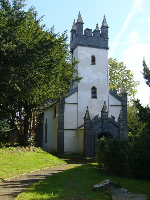
This is a photo of listed building number 11971. |
Summary
| Description |
English: Capel Colman. To quote from a leaflet available at the chapel: "In 1764 Morgan Jones the Elder, master of the nearby Cilwendeg Estate, was responsible for completely rebuilding the long neglected medieval chapel called Capel Colman at the western perimeter of Cilwendeg Park - a church so remote and forgotten that in 1721 it was singled out as being fit 'only for the solitary habitations of Owles and Jackdaws'. Morgan Jones the Younger again rebuilt the church in 1833-5 to the designs of one of his estate tenants, Daniel Davies of Blaenpwllddu Farm."
This was essentially a private chapel for the estate, the local parish church was the 572000 less than a mile away. Today St. Michael's is in ruins and this chapel is still in use for regular worship. |
| Date | |
| Source | From geograph.org.uk |
| Author | Roger W Haworth |
| Attribution (required by the license) | Roger W Haworth / Capel Colman / |
| Camera location | | View this and other nearby images on: OpenStreetMap |
|---|
_heading:112.00&language=en)
| Object location | | View this and other nearby images on: OpenStreetMap |
|---|
_heading:112.00&language=en)
Licensing

|
This image was taken from the Geograph project collection. See this photograph's page on the Geograph website for the photographer's contact details. The copyright on this image is owned by Roger W Haworth and is licensed for reuse under the Creative Commons Attribution-ShareAlike 2.0 license.
|
This file is licensed under the Creative Commons Attribution-Share Alike 2.0 Generic license.
Attribution: Roger W Haworth
- You are free:
- to share – to copy, distribute and transmit the work
- to remix – to adapt the work
- Under the following conditions:
- attribution – You must give appropriate credit, provide a link to the license, and indicate if changes were made. You may do so in any reasonable manner, but not in any way that suggests the licensor endorses you or your use.
- share alike – If you remix, transform, or build upon the material, you must distribute your contributions under the same or compatible license as the original.
File history
Click on a date/time to view the file as it appeared at that time.
| Date/Time | Thumbnail | Dimensions | User | Comment | |
|---|---|---|---|---|---|
| current | 16:24, 25 December 2011 | | 480 × 640 (98 KB) | Rotatebot | Bot: Reset EXIF-specified Orientation of image (EXIF-Orientation set from 6 to 1, rotated 0°) |
| 09:37, 6 February 2011 |  | 640 × 480 (98 KB) | GeographBot | == {{int:filedesc}} == {{Information |description={{en|1=Capel Colman To quote from a leaflet available at the chapel: "In 1764 Morgan Jones the Elder, master of the nearby Cilwendeg Estate, was responsible for completely rebuilding the long neglected med |
File usage
The following pages on the English Wikipedia use this file (pages on other projects are not listed):
Global file usage
The following other wikis use this file:
- Usage on cy.wikipedia.org
- Usage on www.wikidata.org