
Size of this PNG preview of this SVG file: 800 × 560 pixels. Other resolutions: 320 × 224 pixels | 640 × 448 pixels | 1,024 × 716 pixels | 1,280 × 895 pixels | 2,560 × 1,791 pixels | 992 × 694 pixels.
Original file (SVG file, nominally 992 × 694 pixels, file size: 3.05 MB)
| This is a file from the Wikimedia Commons. Information from its description page there is shown below. Commons is a freely licensed media file repository. You can help. |
Summary
| Description |
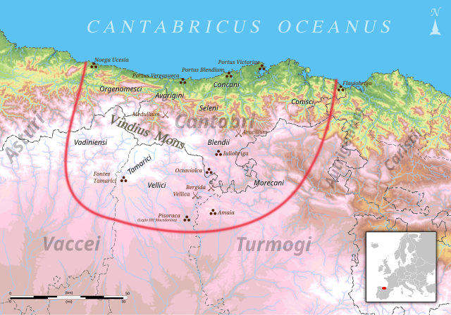
English: Roman Cantabria during the Cantabrian Wars. The map indicates the borders of the cantabrian territory in relation to the present Cantabria as well as the different tribes who inhabited it, the neighboring people, towns and geographic features. Español: Cantabria durante el periodo de las Guerras Cántabras. El mapa señala las fronteras aproximadas del territorio cántabro en relación con la Cantabria actual así como las distintas tribus que lo habitaban, los pueblos vecinos, ciudades y accidentes geográficos interpretados a partir de fuentes clásicas.
Versión corregida y ampliada de Cantabros.png: Français : La Cantabrie durant la période des Guerres cantabres. La carte montre les frontières approximatives du territoire cantabre en relation avec la Cantabrie actuelle, ainsi que les différentes tribus qui y habitent, les peuples voisins, les villes et le relief à partir des sources de l'époque antique. |
| Date | |
| Source | Own work |
| Author | Emilio Gómez Fernández |
| SVG development |

Licensing
I, the copyright holder of this work, hereby publish it under the following license:
This file is licensed under the Creative Commons Attribution-Share Alike 3.0 Unported license.
- You are free:
- to share – to copy, distribute and transmit the work
- to remix – to adapt the work
- Under the following conditions:
- attribution – You must give appropriate credit, provide a link to the license, and indicate if changes were made. You may do so in any reasonable manner, but not in any way that suggests the licensor endorses you or your use.
- share alike – If you remix, transform, or build upon the material, you must distribute your contributions under the same or compatible license as the original.
File history
Click on a date/time to view the file as it appeared at that time.
| Date/Time | Thumbnail | Dimensions | User | Comment | |
|---|---|---|---|---|---|
| current | 09:21, 6 May 2018 | | 992 × 694 (3.05 MB) | GKFX | Fix markup errors, cleanup. |
| 15:26, 13 February 2013 |  | 992 × 694 (3.13 MB) | Tony Rotondas | Se han actualizado al latín los nombres de las tribus que aún estaba en español. | |
| 12:38, 31 December 2012 |  | 992 × 694 (3.13 MB) | Tony Rotondas | Nuevo contenido y correcciones de texto. | |
| 22:11, 21 December 2012 |  | 992 × 694 (3.13 MB) | Tony Rotondas | Añadido alguna tribu más. | |
| 22:06, 21 December 2012 |  | 992 × 694 (3.13 MB) | Tony Rotondas | User created page with UploadWizard |
File usage
The following pages on the English Wikipedia use this file (pages on other projects are not listed):
Global file usage
The following other wikis use this file:
- Usage on ast.wikipedia.org
- Usage on be.wikipedia.org
- Usage on bg.wikipedia.org
- Usage on br.wikipedia.org
- Usage on ca.wikipedia.org
- Usage on cs.wikipedia.org
- Usage on de.wikipedia.org
- Usage on el.wikipedia.org
- Usage on eo.wikipedia.org
- Usage on es.wikipedia.org
- Usage on eu.wikipedia.org
- Usage on fr.wikipedia.org
- Usage on gl.wikipedia.org
- Usage on hu.wikipedia.org
- Usage on it.wikipedia.org
- Usage on ja.wikipedia.org
- Usage on kk.wikipedia.org
View more global usage of this file.