
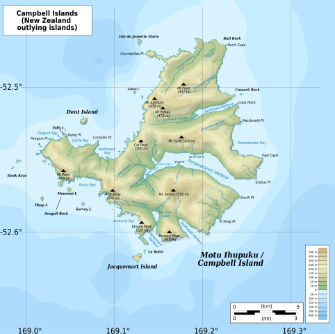
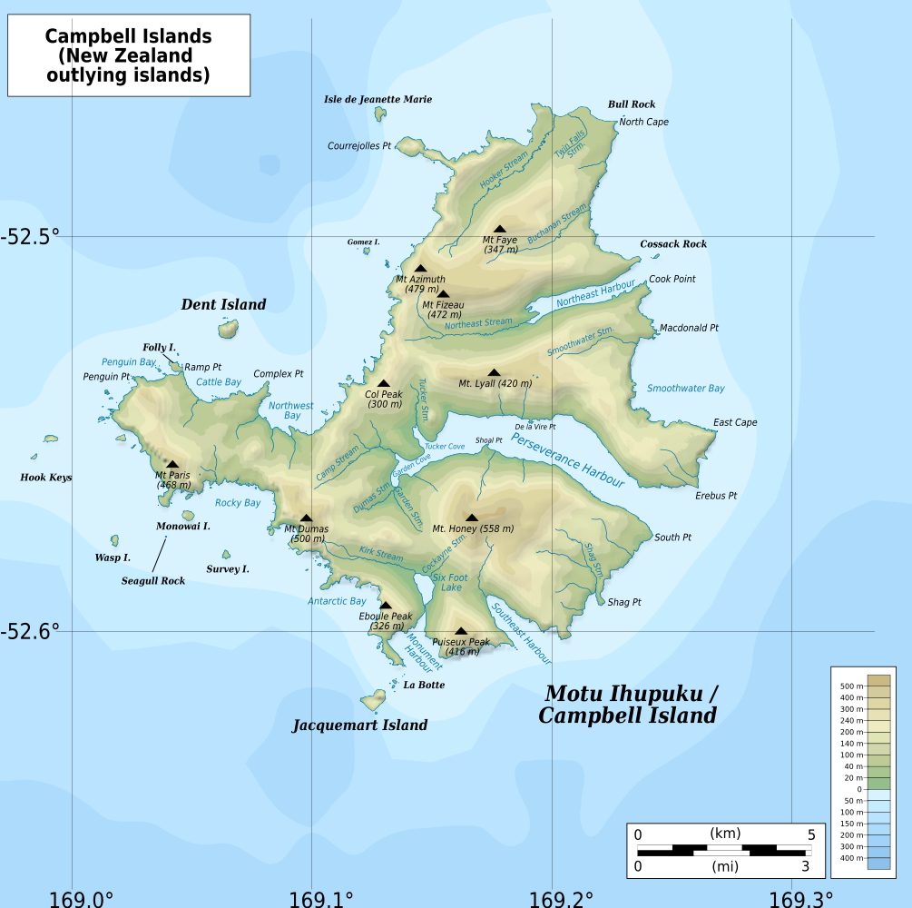
Size of this PNG preview of this SVG file: 603 × 600 pixels. Other resolutions: 241 × 240 pixels | 482 × 480 pixels | 772 × 768 pixels | 1,029 × 1,024 pixels | 2,058 × 2,048 pixels | 1,005 × 1,000 pixels.
Original file (SVG file, nominally 1,005 × 1,000 pixels, file size: 755 KB)
| This is a file from the Wikimedia Commons. Information from its description page there is shown below. Commons is a freely licensed media file repository. You can help. |
Summary
| Description |
English: Geographic map of Campbell Islands, New Zealand
Geographic limits of the map:
|
| Date | |
| Source |
Own work
|
| Author | ikonact |
Licensing
| This work contains information from OpenStreetMap, which is made available under the Open Database License (ODbL).
The ODbL does not require any particular license for maps produced from ODbL data. Prior to 1 August 2020, map tiles produced by the OpenStreetMap Foundation were licensed under the CC-BY-SA-2.0 license. Maps produced by other people may be subject to other licences. |
I, the copyright holder of this work, hereby publish it under the following license:
This file is licensed under the Creative Commons Attribution-Share Alike 4.0 International license.
- You are free:
- to share – to copy, distribute and transmit the work
- to remix – to adapt the work
- Under the following conditions:
- attribution – You must give appropriate credit, provide a link to the license, and indicate if changes were made. You may do so in any reasonable manner, but not in any way that suggests the licensor endorses you or your use.
- share alike – If you remix, transform, or build upon the material, you must distribute your contributions under the same or compatible license as the original.
File history
Click on a date/time to view the file as it appeared at that time.
| Date/Time | Thumbnail | Dimensions | User | Comment | |
|---|---|---|---|---|---|
| current | 22:30, 12 February 2022 | | 1,005 × 1,000 (755 KB) | Ikonact | == {{int:filedesc}} == {{Information |description={{en|1=Geographic map of {{W|Campbell Islands}}, {{W|New Zealand}} Geographic limits of the map: * N: 52.44° S * S: 52.67° S * W: 168.97° E * E: 169.35° E}} |date=2022-02-12 |source={{own}} *Bathymetry: ETOPO1 Public domain *Relief: [https://data.linz.govt.nz/layer/50927-nz-campbell-island-motu-ihupuku-contours-topo-150k/ NZ Campbell Island/Motu Ihupuku Contours: Land Information New Zealand] © Creative Commons Attribution 4.0 International *C... |
File usage
The following pages on the English Wikipedia use this file (pages on other projects are not listed):
Global file usage
The following other wikis use this file:
- Usage on ar.wikipedia.org
- Usage on ca.wikipedia.org
- Usage on fr.wikipedia.org
- Usage on gl.wikipedia.org
- Usage on hr.wikipedia.org
- Usage on www.wikidata.org