
Size of this preview: 800 × 389 pixels. Other resolutions: 320 × 156 pixels | 640 × 311 pixels | 1,024 × 498 pixels.
Original file (1,024 × 498 pixels, file size: 259 KB, MIME type: image/jpeg)
| This is a file from the Wikimedia Commons. Information from its description page there is shown below. Commons is a freely licensed media file repository. You can help. |
Summary
| Description |
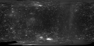
Polski: Mapa powierzchni Kallisto, bez ramki i zmniejszona w celu użycia w szablonach, przede wszystkim lokalizacyjnych. Oparta o dane z misji Galileo i Voyager.
English: Map of Callisto, cropped and rescaled for use in templates, especially location maps. Based on Galileo and Voyager data. |
| Date | |
| Source | Callisto Galileo / Voyager Simple Cylindrical Global Map |
| Author | USGS Astrogeology Science Center |
Licensing
This image is in the public domain in the United States because it only contains materials that originally came from the United States Geological Survey, an agency of the United States Department of the Interior. For more information, see the official USGS copyright policy.
|
File history
Click on a date/time to view the file as it appeared at that time.
| Date/Time | Thumbnail | Dimensions | User | Comment | |
|---|---|---|---|---|---|
| current | 13:36, 14 March 2019 | | 1,024 × 498 (259 KB) | Szczureq | User created page with UploadWizard |
File usage
The following pages on the English Wikipedia use this file (pages on other projects are not listed):
Global file usage
The following other wikis use this file:
- Usage on pl.wikipedia.org
- Usage on pl.wikibooks.org