No higher resolution available.
Cal_poppy_scenic_route_sign.jpg (500 × 473 pixels, file size: 70 KB, MIME type: image/jpeg)
| This is a file from the Wikimedia Commons. Information from its description page there is shown below. Commons is a freely licensed media file repository. You can help. |
Summary
| Description |
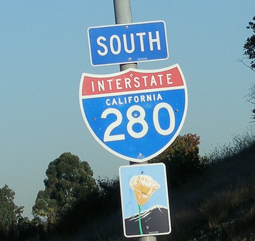
English: An example of how a California poppy sign is used by Caltrans to mark scenic routes in the state of California. This particular example is posted on Interstate 280 southbound, just south of the Farm Hill Boulevard interchange. |
| Date | |
| Source | Own work |
| Author | Coolcaesar |
Licensing
Coolcaesar at the English-language Wikipedia, the copyright holder of this work, hereby publishes it under the following license:
| This file is licensed under the Creative Commons Attribution-Share Alike 3.0 Unported license. Subject to disclaimers. | ||
| Attribution: Coolcaesar at the English-language Wikipedia | ||
| ||
| This licensing tag was added to this file as part of the GFDL licensing update. |

|
Permission is granted to copy, distribute and/or modify this document under the terms of the GNU Free Documentation License, Version 1.2 or any later version published by the Free Software Foundation; with no Invariant Sections, no Front-Cover Texts, and no Back-Cover Texts. A copy of the license is included in the section entitled GNU Free Documentation License. Subject to disclaimers. |
Original upload log
Transferred from en.wikipedia to Commons by Kelly using CommonsHelper.
The original description page was here. All following user names refer to en.wikipedia.
- 2005-10-09 05:30 Coolcaesar 500×473 (71753 bytes) An example of how a [[California poppy]] sign is used by [[Caltrans]] to mark scenic routes in the state of [[California]]. This particular example is posted on [[Interstate 280 (California)]] southbound, just south of the Farm Hill Boulevard interchan
File history
Click on a date/time to view the file as it appeared at that time.
| Date/Time | Thumbnail | Dimensions | User | Comment | |
|---|---|---|---|---|---|
| current | 15:57, 18 July 2011 | | 500 × 473 (70 KB) | File Upload Bot (Magnus Manske) | {{BotMoveToCommons|en.wikipedia|year={{subst:CURRENTYEAR}}|month={{subst:CURRENTMONTHNAME}}|day={{subst:CURRENTDAY}}}} {{Information |Description={{en|An example of how a en:California poppy sign is used by en:Caltrans to mark scenic routes i |
File usage
The following pages on the English Wikipedia use this file (pages on other projects are not listed):