.jpg)
.jpg&action=edit&redlink=1)

Size of this preview: 425 × 600 pixels. Other resolutions: 170 × 240 pixels | 340 × 480 pixels | 1,020 × 1,440 pixels.
Original file (1,020 × 1,440 pixels, file size: 1.66 MB, MIME type: image/jpeg)
| This is a file from the Wikimedia Commons. Information from its description page there is shown below. Commons is a freely licensed media file repository. You can help. |
.jpg)
Summary
| Description |
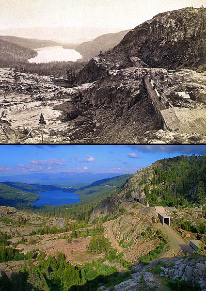
English: Composite image of Donner Summit and Donner Lake with the CPRR grade visible on the right exiting the Summit Tunnel (Tunnel #6) passing through Tunnel #7 and entering Tunnel #8. The upper image, which was taken c1869 by A.J. Russell, shows the grade covered by wooden snow sheds. The lower image was taken by the uploader (Centpacrr) in August, 2003, which shows where the rails of Track #1 had been in place and in daily use from 1868 until the 6.7 mile section of Track #1 between Shed 26 (MP 192.1) and Shed #47 (MP 198.8) about a mile east of the Eder flyover was removed by the UPRR (which now owns the grade) in 1996. All traffic over the summit moved since then over Track #2 about one mile south of Donner Pass and crosses the summit through the 10,322-foot long Tunnel #41 (built in 1925) running under Mt. Judah between Soda Springs and Eder. (The west portal of the Summit Tunnel appears in the lower right corner of each image.)
|
| Date | 20 March 2013 (original upload date) |
| Source | Transferred from en.wikipedia to Commons. |
| Author | Centpacrr at English Wikipedia |
Licensing
This media file is in the public domain in the United States. This applies to U.S. works where the copyright has expired, often because its first publication occurred prior to January 1, 1929, and if not then due to lack of notice or renewal. See this page for further explanation.
|
 | |
 |
This image might not be in the public domain outside of the United States; this especially applies in the countries and areas that do not apply the rule of the shorter term for US works, such as Canada, Mainland China (not Hong Kong or Macao), Germany, Mexico, and Switzerland. The creator and year of publication are essential information and must be provided. See Wikipedia:Public domain and Wikipedia:Copyrights for more details.
|
Centpacrr at English Wikipedia, the copyright holder of this work, hereby publishes it under the following licenses:
This file is licensed under the Creative Commons Attribution-Share Alike 3.0 Unported license.
Attribution: Centpacrr at English Wikipedia
- You are free:
- to share – to copy, distribute and transmit the work
- to remix – to adapt the work
- Under the following conditions:
- attribution – You must give appropriate credit, provide a link to the license, and indicate if changes were made. You may do so in any reasonable manner, but not in any way that suggests the licensor endorses you or your use.
- share alike – If you remix, transform, or build upon the material, you must distribute your contributions under the same or compatible license as the original.

|
Permission is granted to copy, distribute and/or modify this document under the terms of the GNU Free Documentation License, Version 1.2 or any later version published by the Free Software Foundation; with no Invariant Sections, no Front-Cover Texts, and no Back-Cover Texts. A copy of the license is included in the section entitled GNU Free Documentation License. |
You may select the license of your choice.
Original upload log
The original description page was here. All following user names refer to en.wikipedia.
| Date/Time | Dimensions | User | Comment |
|---|---|---|---|
| 2013-03-20 02:00 | 1020×1440× (1744325 bytes) | Centpacrr | Composite image of [[Donner Summit]] and [[Donner Lake]] with the [[Central Pacific Railroad|CPRR]] grade visible on the right exiting the Summit Tunnel (Tunnel #6) passing through Tunnel #7 and entering Tunnel #8. The upper image, which was taken c186... |
File history
Click on a date/time to view the file as it appeared at that time.
| Date/Time | Thumbnail | Dimensions | User | Comment | |
|---|---|---|---|---|---|
| current | 03:19, 28 February 2016 | | 1,020 × 1,440 (1.66 MB) | FastilyClone | Transferred from enwp |
File usage
The following pages on the English Wikipedia use this file (pages on other projects are not listed):
Global file usage
The following other wikis use this file:
- Usage on hu.wikipedia.org
.jpg)