Size of this preview: 800 × 508 pixels. Other resolutions: 320 × 203 pixels | 640 × 406 pixels | 1,024 × 650 pixels | 1,280 × 813 pixels | 2,560 × 1,625 pixels | 5,118 × 3,249 pixels.
Original file (5,118 × 3,249 pixels, file size: 1.95 MB, MIME type: image/jpeg)
| This is a file from the Wikimedia Commons. Information from its description page there is shown below. Commons is a freely licensed media file repository. You can help. |
| Description |
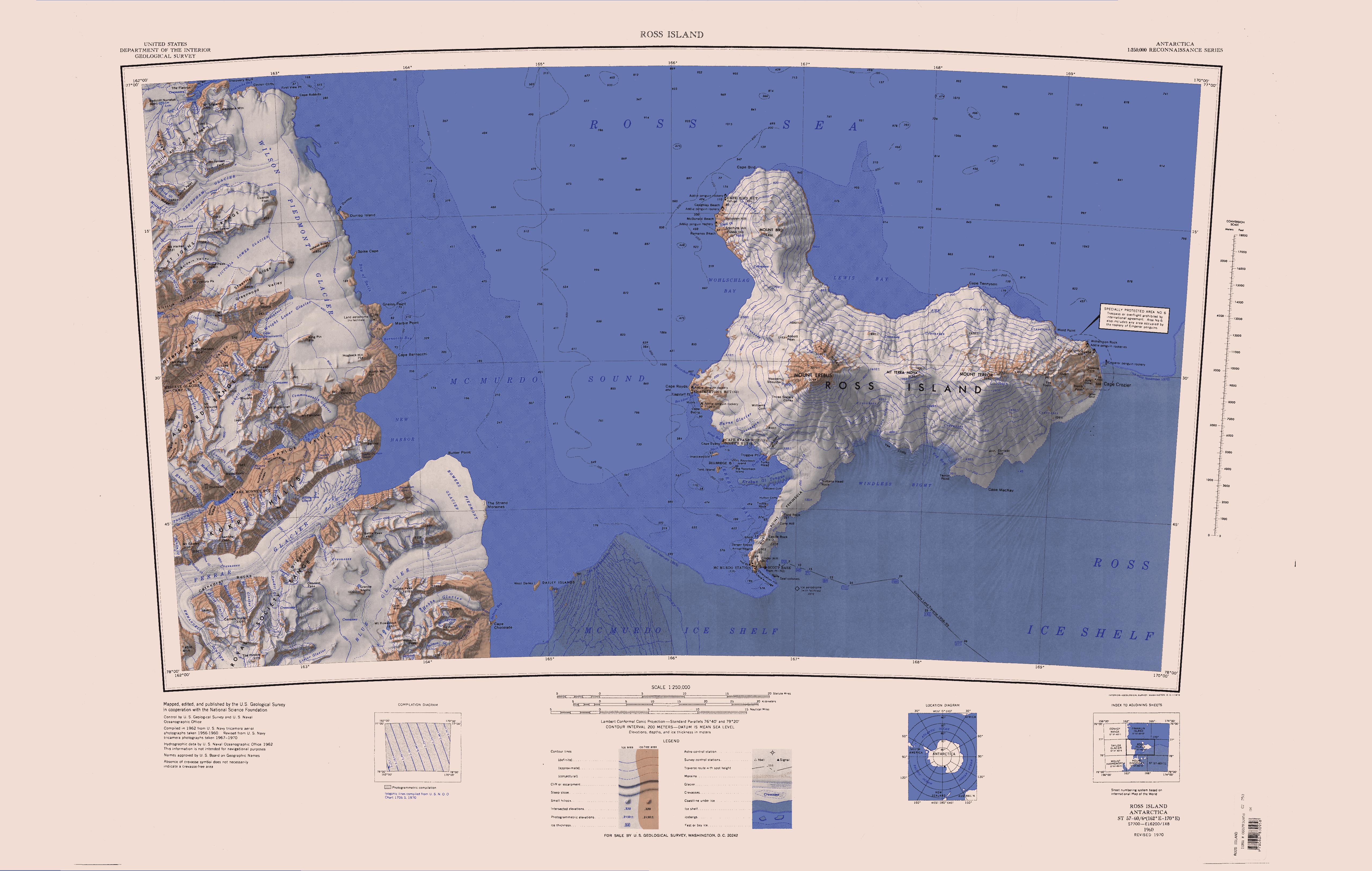
English: Map of Antarctica by the United States Antarctic Resource Center of the US Geological Society. |
| Source | USGS |
| Author | USGS |
| Other versions | File:Ross Island Topographic Map USGS.png : Higher quality PNG version |
This image is in the public domain in the United States because it only contains materials that originally came from the United States Geological Survey, an agency of the United States Department of the Interior. For more information, see the official USGS copyright policy.
|
File history
Click on a date/time to view the file as it appeared at that time.
| Date/Time | Thumbnail | Dimensions | User | Comment | |
|---|---|---|---|---|---|
| current | 12:01, 15 April 2005 | | 5,118 × 3,249 (1.95 MB) | Achim Raschka | Map of Antarctica by the United States Antarctic Ressource Center of the US Geological Society. {{PD-US}} Copyrights and Trademarks USGS-authored or produced data and information are in the public domain. While the content of most USGS web pages is in th |
File usage
The following pages on the English Wikipedia use this file (pages on other projects are not listed):
- Asgard Range
- Bettle Peak
- Blue Glacier (Antarctica)
- Briggs Hill
- Cathedral Rocks
- Denton Hills
- Ferrar Glacier
- Flint Ridge
- Garwood Valley
- Gonville and Caius Range
- Granite Harbour
- Hobbs Ridge
- Horowitz Ridge
- Keble Hills
- Koettlitz Glacier
- Kukri Hills
- MacDonald Hills
- Mackay Glacier
- Mount Falconer
- Mount Lister
- Mount Newall
- New Harbour (Antarctica)
- Newall Glacier
- Olympus Range
- Roa Ridge
- Royal Society Range
- Saint Johns Range
- Table Mountain (Antarctica)
- Taylor Glacier
- Taylor Valley
- Victoria Valley
- Wilson Piedmont Glacier
- Wright Valley
Global file usage
The following other wikis use this file:
- Usage on ceb.wikipedia.org
- Usage on de.wikipedia.org
- Meserve-Gletscher
- Antarktische Trockentäler
- Tschadsee (Antarktika)
- Dailey Islands
- Marble Point
- Kap Roberts
- Wilson-Piedmont-Gletscher
- Kap Bernacchi
- Bernacchi-Bucht
- Bowers-Piedmont-Gletscher
- Blue Glacier
- Denton Hills
- Staeffler Ridge
- Matterhorn (Viktorialand)
- Lacroix-Gletscher
- Matterhorn-Gletscher
- Debenham-Gletscher
- Gonville and Caius Range
- Arnold Cove
- Gneiss Point
- Redcliff-Nunatak
- Borns-Gletscher
- Mount Coates (Viktorialand)
- Briggs Hill
- Descent-Pass
- Brodie Ponds
- Kuechle Island
- West Dailey Island
- Usage on fr.wikipedia.org
- Usage on he.wikipedia.org
- Usage on it.wikipedia.org
- Ghiacciaio Ferrar
- Ghiacciaio Taylor (Terra Vittoria)
- New Harbor
- Ghiacciaio Debenham
- Ghiacciaio Wright inferiore
- Ghiacciaio Erebus
- Ghiacciaio Canada
- Piattaforma di ghiaccio McMurdo
- Ghiacciaio Aiken
- Ghiacciaio Von Guerard
- Ghiacciaio Mezzaluna
- Ghiacciaio Salmon
- Ghiacciaio Blackwelder
- Ghiacciaio Hobbs (Dipendenza di Ross)
- Ghiacciaio Geodetic
View more global usage of this file.