File:Brazil Provinces 1889.svg

Original file(SVG file, nominally 2,008 × 1,984 pixels, file size: 1.13 MB)

Description
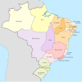
English: Map of the provinces of the Empire of Brazil in 1889.
Deutsch: Karte der Provinzen des Kaiserreichs Brasilien im Jahre 1889.
Date
Source Modification of Brazil, administrative divisions (regions+states) - de - colored.svg
Author

TUBS

Permission
(Reusing this file)
I, the copyright holder of this work, hereby publish it under the following license:
w:en:Creative Commons
attribution share alike
This file is licensed under the Creative Commons Attribution-Share Alike 3.0 Unported license.
You are free:
  • to share – to copy, distribute and transmit the work
  • to remix – to adapt the work
Under the following conditions:
  • attribution – You must give appropriate credit, provide a link to the license, and indicate if changes were made. You may do so in any reasonable manner, but not in any way that suggests the licensor endorses you or your use.
  • share alike – If you remix, transform, or build upon the material, you must distribute your contributions under the same or compatible license as the original.
I'd greatly appreciate, that you attribute this media file to Wikimedia Commons, if used outside Wikipedia or Commons. For use in publications such as books, newspapers, blogs, websites, please insert here the following line:
{{published|author= |date= |url= |title= |org= }}
and fill the applicable fields. (Example). License terms given above still apply.

বাংলা  Deutsch  Deutsch (Sie-Form)  Ελληνικά  English  español  français  Ἀρχαία ἑλληνικὴ  Bahasa Indonesia  日本語  македонски  Nederlands  português  русский  Türkçe  简体中文  繁體中文  +/−

Other versions Brazil, administrative divisions (regions+states) - de - colored.svg

Captions

Map of the provinces of the Brazilian Empire during 1889

Items portrayed in this file

depicts

16 June 2015

image/svg+xml

c6eec49deb41ae45a61f95176c3317f166bf50a9

1,185,788 byte

1,984 pixel

2,008 pixel

File history

Click on a date/time to view the file as it appeared at that time.

Date/TimeThumbnailDimensionsUserComment
current12:34, 16 June 2015Thumbnail for version as of 12:34, 16 June 20152,008 × 1,984 (1.13 MB)Master Uegly{{Information |Description ={{en|1=Map of the provinces of the Empire of Brazil in 1889.}} {{de|1=Karte der Provinzen des Kaiserreichs Brasilien im Jahre 1889.}} |Source =Modification of...
The following pages on the English Wikipedia use this file (pages on other projects are not listed):

Global file usage

The following other wikis use this file:

Metadata