No higher resolution available.
Boreray_Coastal_View_-_geograph.org.uk_-_1379935.jpg (640 × 344 pixels, file size: 39 KB, MIME type: image/jpeg)
| This is a file from the Wikimedia Commons. Information from its description page there is shown below. Commons is a freely licensed media file repository. You can help. |
Summary
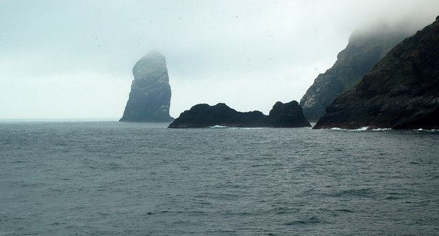
| Description |
English: Boreray Coastal View The island of Sgarbhstac and the rocky point of Gob Scapanais lie inside the square. Stac Lee is shown in the background. Every September, the St Kildans would undertake the dangerous task of hunting the young Gannets, or Gugas, on Boreray and its two great stacks. They had to climb the steep cliffs, barefoot, at night. The night's kill was thrown into the sea for the boat to collect, with some birds left in cleits as a food supply for the next expedition to the island. Women climbed Boreray too, and could carry a sheep or lambs while doing so. (Source: "The Life and Death of St Kilda", by Tom Steel) |
| Date | |
| Source | From geograph.org.uk |
| Author | Mary and Angus Hogg |
| Attribution (required by the license) | Mary and Angus Hogg / Boreray Coastal View / |
| Camera location | | View this and other nearby images on: OpenStreetMap |
|---|
_heading:292.00&language=en)
| Object location | | View this and other nearby images on: OpenStreetMap |
|---|
_heading:292.00&language=en)
Licensing

|
This image was taken from the Geograph project collection. See this photograph's page on the Geograph website for the photographer's contact details. The copyright on this image is owned by Mary and Angus Hogg and is licensed for reuse under the Creative Commons Attribution-ShareAlike 2.0 license.
|
This file is licensed under the Creative Commons Attribution-Share Alike 2.0 Generic license.
Attribution: Mary and Angus Hogg
- You are free:
- to share – to copy, distribute and transmit the work
- to remix – to adapt the work
- Under the following conditions:
- attribution – You must give appropriate credit, provide a link to the license, and indicate if changes were made. You may do so in any reasonable manner, but not in any way that suggests the licensor endorses you or your use.
- share alike – If you remix, transform, or build upon the material, you must distribute your contributions under the same or compatible license as the original.
File history
Click on a date/time to view the file as it appeared at that time.
| Date/Time | Thumbnail | Dimensions | User | Comment | |
|---|---|---|---|---|---|
| current | 14:09, 28 February 2011 | | 640 × 344 (39 KB) | GeographBot | == {{int:filedesc}} == {{Information |description={{en|1=Boreray Coastal View The island of Sgarbhstac and the rocky point of Gob Scapanais lie inside the square. Stac Lee is shown in the background. Every September, the St Kildans would undertake the d |
File usage
The following pages on the English Wikipedia use this file (pages on other projects are not listed):
Global file usage
The following other wikis use this file:
- Usage on fy.wikipedia.org
- Usage on gd.wikipedia.org