
Size of this PNG preview of this SVG file: 800 × 495 pixels. Other resolutions: 320 × 198 pixels | 640 × 396 pixels | 1,024 × 633 pixels | 1,280 × 791 pixels | 2,560 × 1,583 pixels | 959 × 593 pixels.
Original file (SVG file, nominally 959 × 593 pixels, file size: 32 KB)
| This is a file from the Wikimedia Commons. Information from its description page there is shown below. Commons is a freely licensed media file repository. You can help. |
Summary
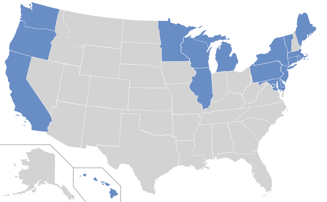
| Description | map of the US states showing the ones that were part of the “Blue Wall” between the 1992 and 2020 United States presidential elections, with the exception of the 2016 United States presidential election. |
| Date | |
| Source | made from the file Blank US Map (states only).svg |
| Author | User:MaGioZal |
.svg&action=edit&redlink=1)
Licensing
| I, the copyright holder of this work, release this work into the public domain. This applies worldwide. In some countries this may not be legally possible; if so: I grant anyone the right to use this work for any purpose, without any conditions, unless such conditions are required by law. |
File history
Click on a date/time to view the file as it appeared at that time.
| Date/Time | Thumbnail | Dimensions | User | Comment | |
|---|---|---|---|---|---|
| current | 05:59, 9 March 2023 | | 959 × 593 (32 KB) | Unknown-Tree | Reverted to version as of 11:46, 18 January 2017 (UTC) |
| 05:49, 9 March 2023 |  | 959 × 593 (34 KB) | Unknown-Tree | Make 2016 Trump states lighter blue | |
| 11:46, 18 January 2017 |  | 959 × 593 (32 KB) | MaGioZal | {{Information |Description= map of the US states showing the ones that were part of the [http://en.wikipedia.org/wiki/Blue_wall_(politics) “Blue Wall”] between the 1992 and 2012 presidential elections |Source= made from the file Blank US Map (state... |
File usage
The following pages on the English Wikipedia use this file (pages on other projects are not listed):
Global file usage
The following other wikis use this file:
- Usage on de.wikipedia.org
- Usage on es.wikipedia.org
- Usage on he.wikipedia.org
- Usage on pt.wikipedia.org
- Usage on tr.wikipedia.org
- Usage on www.wikidata.org