
Original file (SVG file, nominally 581 × 581 pixels, file size: 532 KB)
| This is a file from the Wikimedia Commons. Information from its description page there is shown below. Commons is a freely licensed media file repository. You can help. |

.svg)
.svg&action=edit&redlink=1)
.svg)
Summary
| Description |
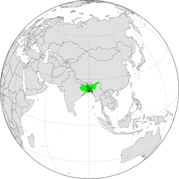
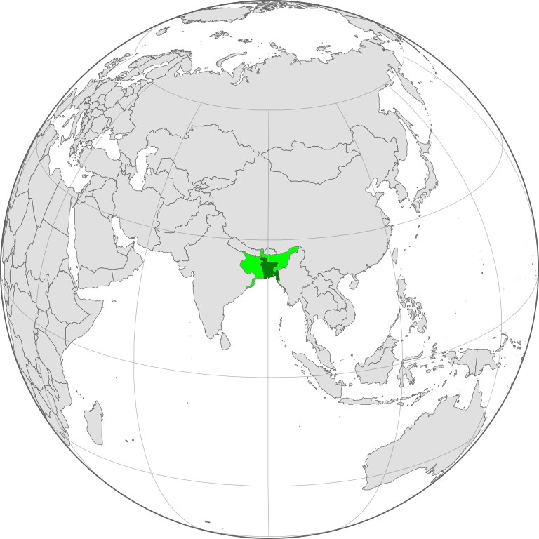
English: Bengal is a geopolitical, cultural and historical region in Asia, which is located in South Asia at the apex of the Bay of Bengal.
Geographically, it is made up by the Ganges-Brahmaputra delta system, the largest such formation in the world; along with mountains in its north bordering the Himalayan states of Nepal and Bhutan and east bordering Burma.Politically, Bengal is now divided between the sovereign Republic of Bangladesh and India. Bangladesh a sovereign state the name means 'Bengali Country' or 'Country of Bengal' In spite of a last-ditch effort to form a United Bengal, when India gained independence in 1947, Bengal was partitioned along religious lines. Bengal was conquered by the British East India Company in the Battle of Palasy 1757 and and became the Bengal Presidency, which experienced deindustrialization and famines under British rule. Bengal played a major role in the Indian independence movement, in which revolutionary groups were dominant. Armed attempts to overthrow the British Raj began with the rebellion of Titumir, and reached a climax when Subhas Chandra Bose led the Indian National Army against the British. Bengal was also central in the rising political awareness of the Muslim population—the All-India Muslim League was established in Dhaka in 1906. The United Kingdom Cabinet Mission of 1946 to British Raj aimed to discuss the transfer of power from the British government to the Indian leadership. Bengali Prime Minister Huseyn Shaheed Suhrawardy and nationalist leader Sarat Chandra Bose wanted to found a united and independent nation-state of Bengal. The proposal was floated as an alternative to the partition of Bengal on communal lines. The initiative failed due to British diplomacy and communal conflict between Muslims and Hindus that eventually led to the second partition of Bengal.  The Partition of Bengal Presidency in 1947 resulted in Bengal's division on religious grounds, between the India and Pakistan prominently called Radcliffe's line.
and the Princely state of Tripura, Naga hills, Manipur,coch Bihar, Khasi state under the protection of India. Radcliffe's line split Bengal, which historically was always a single economic zone, single cultural and ethnic (Bengali-Hindu or Bengali-Muslim) zone, into two halves. The two-halves were intricately connected with each other. The fertile East produced food and raw materials which the West consumed and the industrialized West produced manufactured goods which were consumed by the East. This mutually beneficial trade and exchange was severely disrupted by the partition. Rail, road and water communication routes were severed between the two. The predominant ethno-linguistic group is the Bengali people, who speak the Indo-Aryan Bengali language.বাংলা: বঙ্গ, বেঙ্গল বাংলা, বঙ্গদেশ হচ্ছে দক্ষিণ এশিয়ার উত্তরপূর্বে অবস্থিত একটি ঐতিহাসিক এবং ভৌগোলিক অঞ্চল। এই বঙ্গ বর্তমানে একটি স্বতন্ত্র রাষ্ট্র বাংলাদেশ এবং ভারত দ্বারা গঠিত। কিন্তু পূর্বে অবিভক্ত বাংলার বেশ কিছু অঞ্চল বর্তমানে পশ্চিমবঙ্গের পার্শ্ববর্তী ভারতীয় রাজ্য বিহার, অসম ও ওড়িশা অন্তর্ভুক্ত ছিল।
বাঙালি জাতি বা বাঙ্গালি জাতি হল বঙ্গ অর্থাৎ বাংলাদেশ ও ভারতের পশ্চিমবঙ্গ, ত্রিপুরা, অসম ও আন্দামান ও নিকোবর দ্বীপপুঞ্জে বসবাসকারী মানব সম্প্রদায় যাদের ইতিহাস অন্ততঃ চার হাজার বছর পুরোনো। এদের মাতৃভাষা বাংলা। এই নৃগোষ্ঠীর সর্বাধিক ঘনত্ব দেখা যায় অধুনা বাংলাদেশ ও ভারতবর্ষের পশ্চিমবঙ্গ রাজ্যে। তবে এছাড়াও অনেক বাঙালি ছড়িয়ে ছিটিয়ে আছে ভারতের আরো নানা রাজ্যে, যেমনঃ ত্রিপুরা, আসাম, ঝাড়খণ্ড, বিহার, উড়িষ্যা, উত্তর প্রদেশ, মহারাষ্ট্র, দিল্লী, কর্ণাটক এবং ভারতের উত্তরপূর্ব সীমান্তের রাজ্যগুলিতে (অরুণাচল প্রদেশ, মণিপুর, মেঘালয়, মিজোরাম, নাগাল্যান্ড)। |
| Date | |
| Source | Own work based on: Blankmap-ao-270W-asia.png and Bengal Presidency 1858.png |
| Author | Aziz Tarak. |
| Permission (Reusing this file) |
I, the copyright holder of this work, hereby publish it under the following license: This file is licensed under the Creative Commons Attribution-Share Alike 4.0 International license.
|
Licensing
- You are free:
- to share – to copy, distribute and transmit the work
- to remix – to adapt the work
- Under the following conditions:
- attribution – You must give appropriate credit, provide a link to the license, and indicate if changes were made. You may do so in any reasonable manner, but not in any way that suggests the licensor endorses you or your use.
- share alike – If you remix, transform, or build upon the material, you must distribute your contributions under the same or compatible license as the original.
File history
Click on a date/time to view the file as it appeared at that time.
| Date/Time | Thumbnail | Dimensions | User | Comment | |
|---|---|---|---|---|---|
| current | 19:30, 17 August 2018 | | 581 × 581 (532 KB) | Aziz Tarak. | optimized & Border correction according to source |
| 19:35, 8 August 2018 |  | 2,267 × 2,267 (2.22 MB) | Aziz Tarak. | {{Information |description ={{en|1=Bengal is a geopolitical, cultural and historical region in Asia, which is located in South Asia at the apex of the Bay of Bengal. Geographically, it is made up by the Ganges-Brahmaputra delta system, the largest such formation in the world; along with mountains in its north bordering the Himalayan states of Nepal and Bhutan and east bordering Burma.Politically, Bengal is now divided between the sovereign Republic of Bangladesh and India. Bangladesh a sove... |
.svg)