
Size of this PNG preview of this SVG file: 438 × 457 pixels. Other resolutions: 230 × 240 pixels | 460 × 480 pixels | 736 × 768 pixels | 981 × 1,024 pixels | 1,963 × 2,048 pixels.
Original file (SVG file, nominally 438 × 457 pixels, file size: 219 KB)
| This is a file from the Wikimedia Commons. Information from its description page there is shown below. Commons is a freely licensed media file repository. You can help. |
Summary
| Description |
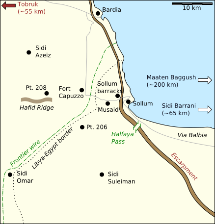
English: A map of the area in which Operations Brevity and Battleaxe were fought |
| Date | |
| Source |
Based on en:File:BattleaxeContestedArea.JPG, with verifiable data from:
|
| Author | Jappalang |
| Other versions |
Derivative works of this file: BattleaxeContestedArea-de.svg en:File:BattleaxeContestedArea.JPG |
Licensing
I, the copyright holder of this work, hereby publish it under the following licenses:
This file is licensed under the Creative Commons Attribution-Share Alike 3.0 Unported license.
- You are free:
- to share – to copy, distribute and transmit the work
- to remix – to adapt the work
- Under the following conditions:
- attribution – You must give appropriate credit, provide a link to the license, and indicate if changes were made. You may do so in any reasonable manner, but not in any way that suggests the licensor endorses you or your use.
- share alike – If you remix, transform, or build upon the material, you must distribute your contributions under the same or compatible license as the original.

|
Permission is granted to copy, distribute and/or modify this document under the terms of the GNU Free Documentation License, Version 1.2 or any later version published by the Free Software Foundation; with no Invariant Sections, no Front-Cover Texts, and no Back-Cover Texts. A copy of the license is included in the section entitled GNU Free Documentation License. |
You may select the license of your choice.
File history
Click on a date/time to view the file as it appeared at that time.
| Date/Time | Thumbnail | Dimensions | User | Comment | |
|---|---|---|---|---|---|
| current | 14:44, 15 June 2014 | | 438 × 457 (219 KB) | Hohum | Cartographic colours |
| 22:55, 2 March 2009 |  | 438 × 457 (219 KB) | Jappalang | Converted fonts (objects) to paths | |
| 22:15, 9 January 2009 |  | 438 × 457 (41 KB) | Jappalang | Enhancement of the country border text | |
| 14:16, 9 January 2009 |  | 438 × 457 (40 KB) | Jappalang | {{Information |Description={{en|1=A map of the area in which Operations Brevity and Battleaxe were fought}} |Source=Based on en:BattleaxeContestedArea.JPG, with verifiable data from Google Maps, en:File:Operation Brevity.jpg, and Jon Latimer and |
File usage
The following pages on the English Wikipedia use this file (pages on other projects are not listed):
Global file usage
The following other wikis use this file:
- Usage on ar.wikipedia.org
- Usage on ca.wikipedia.org
- Usage on es.wikipedia.org
- Usage on fa.wikipedia.org
- Usage on fi.wikipedia.org
- Usage on fr.wikipedia.org
- Usage on he.wikipedia.org
- Usage on it.wikipedia.org
- Usage on ko.wikipedia.org
- Usage on nl.wikipedia.org
- Usage on pl.wikipedia.org
- Usage on ru.wikipedia.org
- Usage on sr.wikipedia.org
- Usage on ta.wikipedia.org
- Usage on vi.wikipedia.org
- Usage on www.wikidata.org
- Usage on zh.wikipedia.org