File:Barkly Tableland Map.png

Original file(1,516 × 1,427 pixels, file size: 699 KB, MIME type: image/png)

Summary

Description
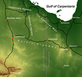
English: This is a map of the Barkly Tableland, which extends from the eastern Northern Territory (near Daly and Newcastle Waters) into Western Queensland (almost to Mt Isa). The map features major highways and selected towns. The background is an elevation model, giving a rough idea of the tableland's area, which is the somewhat uniformly coloured area around the appropriately named Barkly and Tableland Highways. The green in that area corresponds to an elevation of about 200 to 300 metres. Elevation data is from the SRTM30 dataset published by the USGS, thus being in the public domain. The data has been retrieved via http://diva-gis.org/gdata. Roads and populated places have been taken from Natural Earth's 10m cultural vectors set at http://www.naturalearthdata.com/downloads/10m-cultural-vectors/, which is public domain as well. The map was created using ESRI ArcMap 10.2.2.
Date
Source Own work
Author Christallkeks

Licensing

I, the copyright holder of this work, hereby publish it under the following license:
w:en:Creative Commons
attribution share alike
This file is licensed under the Creative Commons Attribution-Share Alike 4.0 International license.
You are free:
  • to share – to copy, distribute and transmit the work
  • to remix – to adapt the work
Under the following conditions:
  • attribution – You must give appropriate credit, provide a link to the license, and indicate if changes were made. You may do so in any reasonable manner, but not in any way that suggests the licensor endorses you or your use.
  • share alike – If you remix, transform, or build upon the material, you must distribute your contributions under the same or compatible license as the original.

Captions

Add a one-line explanation of what this file represents

Items portrayed in this file

depicts

17 January 2016

image/png

30baff0392163cbcae9e04f3313ad5e6a0c27b3a

715,570 byte

1,427 pixel

1,516 pixel

File history

Click on a date/time to view the file as it appeared at that time.

Date/TimeThumbnailDimensionsUserComment
current18:27, 17 January 2016Thumbnail for version as of 18:27, 17 January 20161,516 × 1,427 (699 KB)Christallkeks{{Information |Description ={{en|1=This is a map of the Barkly Tableland, which extends from the eastern Northern Territory (near Daly and Newcastle Waters) into Western Queensland (almost to Mt Isa). The map features major highways and selected tow...
No pages on the English Wikipedia use this file (pages on other projects are not listed).

Global file usage

The following other wikis use this file:

Metadata