Size of this preview: 315 × 598 pixels. Other resolutions: 126 × 240 pixels | 358 × 680 pixels.
Original file (358 × 680 pixels, file size: 609 KB, MIME type: image/png)
| This is a file from the Wikimedia Commons. Information from its description page there is shown below. Commons is a freely licensed media file repository. You can help. |
Summary
| Description |
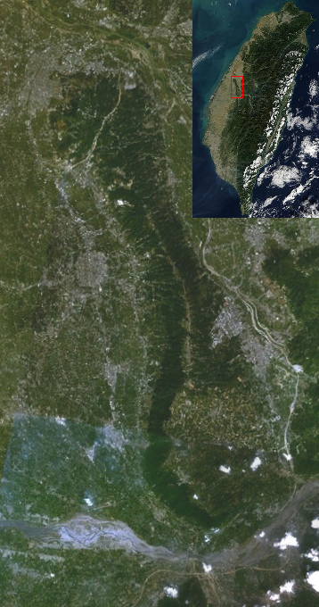
English: Bagua Plateau.It's from a screenshot of NASA World Wind.
中文(繁體):八卦台地衛星空照圖,取自 NASA World Wind。 |
| Source | File:Taichung Basin on Worldwind.png |
| Author | NASA Ames Research Center |
Licensing
| This image is in the public domain because it is a screenshot from NASA’s globe software World Wind using a public domain layer, such as Blue Marble, MODIS, Landsat, SRTM, USGS or GLOBE.
|
 |
| Annotations | This image is annotated: View the annotations at Commons |
File history
Click on a date/time to view the file as it appeared at that time.
| Date/Time | Thumbnail | Dimensions | User | Comment | |
|---|---|---|---|---|---|
| current | 19:36, 6 May 2011 | | 358 × 680 (609 KB) | Yiken | |
| 15:48, 17 April 2011 |  | 358 × 680 (458 KB) | Yiken | {{Information |Description ={{en|1=Bagua Plateau.It's from a screenshot of NASA World Wind.}} {{zh-hant|1=八卦台地衛星空照圖,取自 NASA World Wind。}} |Source =[[:File:Taichung Basin on Worldwind.png|File:Taichung Basin on Worldwin |
File usage
The following pages on the English Wikipedia use this file (pages on other projects are not listed):
Global file usage
The following other wikis use this file:
- Usage on www.wikidata.org
- Usage on zh-min-nan.wikipedia.org
- Usage on zh.wikipedia.org