File:Australian Census 2011 demographic map - Australia by SLA - BCP field 0109 Median age of persons.svg

Size of this PNG preview of this SVG file: 762 × 600 pixels. Other resolutions: 305 × 240 pixels | 610 × 480 pixels | 976 × 768 pixels | 1,280 × 1,007 pixels | 2,560 × 2,015 pixels | 2,000 × 1,574 pixels.
Original file (SVG file, nominally 2,000 × 1,574 pixels, file size: 9.53 MB)
| This is a file from the Wikimedia Commons. Information from its description page there is shown below. Commons is a freely licensed media file repository. You can help. |
Summary
| Description |
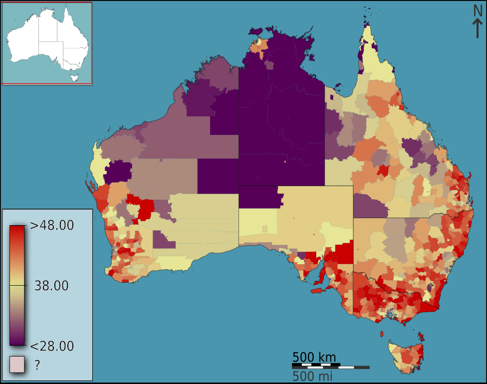
English: Median age as a fraction of raw figure, in Australia, Australia, according to the 2011 census results. The map is divided into geographical subdivisions by Statistical Local Area. Note the split scale above and below the median value. |
||
| Date | |||
| Source |
Own work based on: data from the Australian Bureau of Statistics
|
||
| Author | Toby Hudson | ||
| Other versions | Derivative works of this file: Australian Census Maps icon.jpg | ||
| SVG development | This oversized W3C-invalid census map was created with an unknown SVG tool. |
Licensing
I, the copyright holder of this work, hereby publish it under the following license:
This file is licensed under the Creative Commons Attribution-Share Alike 3.0 Australia license.
Attribution: Toby Hudson based on data from the Australian Bureau of Statistics
- You are free:
- to share – to copy, distribute and transmit the work
- to remix – to adapt the work
- Under the following conditions:
- attribution – You must give appropriate credit, provide a link to the license, and indicate if changes were made. You may do so in any reasonable manner, but not in any way that suggests the licensor endorses you or your use.
- share alike – If you remix, transform, or build upon the material, you must distribute your contributions under the same or compatible license as the original.

File history
Click on a date/time to view the file as it appeared at that time.
| Date/Time | Thumbnail | Dimensions | User | Comment | |
|---|---|---|---|---|---|
| current | 13:34, 11 June 2020 | | 2,000 × 1,574 (9.53 MB) | Leonel Sohns | Reverted to version as of 12:41, 1 July 2013 (UTC) |
| 09:33, 29 October 2017 |  | 2,000 × 1,574 (3.39 MB) | JoKalliauer | made file valid and decreased file size | |
| 12:41, 1 July 2013 |  | 2,000 × 1,574 (9.53 MB) | File Upload Bot (99of9) | =={{int:filedesc}}== {{Information |Description={{en|{{ucfirst:{{Australian2011CensusMaps/bcpfieldcat/109}}}} as a fraction of raw figure, in Australia, Australia, according to the 2011 census results. The map is divided into geographical subdivisions ... |
File usage
The following pages on the English Wikipedia use this file (pages on other projects are not listed):
Global file usage
The following other wikis use this file:
- Usage on de.wikipedia.org
- Usage on es.wikipedia.org
- Usage on ja.wikipedia.org
- Usage on uk.wikipedia.org