Size of this preview: 800 × 512 pixels. Other resolutions: 320 × 205 pixels | 640 × 410 pixels | 898 × 575 pixels.
Original file (898 × 575 pixels, file size: 129 KB, MIME type: image/jpeg)
| This is a file from the Wikimedia Commons. Information from its description page there is shown below. Commons is a freely licensed media file repository. You can help. |
| Description |
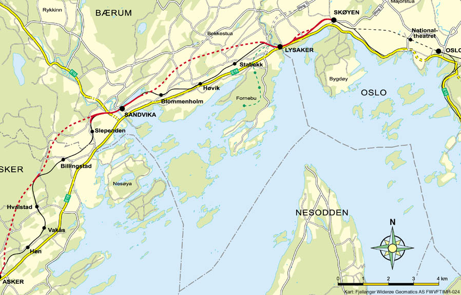
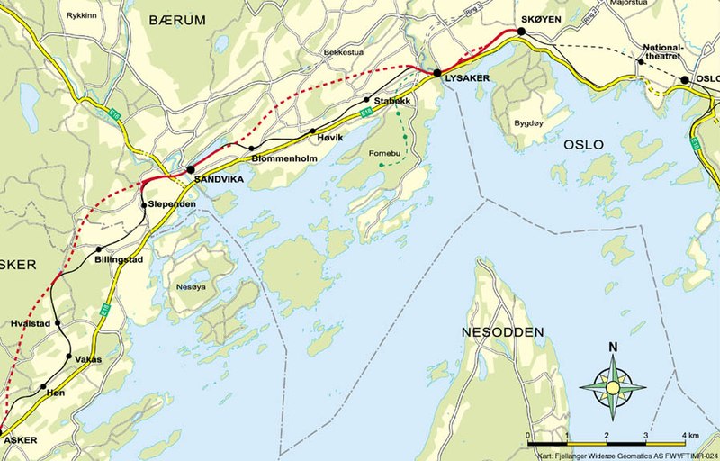
English: Map of the Asker Line west of Oslo, Norway. Red line is the Asker Line and black line is the Drammen Line. Dotted lines are tunnels. Black dots are stations. The green line is the Fornebu Line. The yellow lines indicate European Routes E16 and E18. |
|||
| Source | http://www.jernbaneverket.no/multimedia/archive/01417/Kart_Sk_yen-Asker_1417793a.jpg | |||
| Author | Jernbaneverket / Norwegian National Rail Administration | |||
| Permission (Reusing this file) |
|


|
This map image could be re-created using vector graphics as an SVG file. This has several advantages; see Commons:Media for cleanup for more information. If an SVG form of this image is available, please upload it and afterwards replace this template with
{{vector version available|new image name}}.
It is recommended to name the SVG file “Asker Line map.svg”—then the template Vector version available (or Vva) does not need the new image name parameter. |


File history
Click on a date/time to view the file as it appeared at that time.
| Date/Time | Thumbnail | Dimensions | User | Comment | |
|---|---|---|---|---|---|
| current | 10:56, 7 May 2020 | | 898 × 575 (129 KB) | Tholme | Cropped 3 % horizontally, 5 % vertically using CropTool with lossless mode. Remove border |
| 18:58, 18 November 2008 |  | 926 × 603 (136 KB) | Arsenikk | {{Information |Description={{en|1=Map of the Asker Line west of Oslo, Norway. Red line is the Asker Line and black line is the Drammen Line. Dotted lines are tunnels. Black dots are stati |
File usage
The following pages on the English Wikipedia use this file (pages on other projects are not listed):
Global file usage
The following other wikis use this file:
- Usage on da.wikipedia.org
- Usage on de.wikipedia.org
- Usage on fr.wikipedia.org
- Usage on id.wikipedia.org
- Usage on nl.wikipedia.org
- Usage on nn.wikipedia.org
- Usage on no.wikipedia.org
- Usage on pl.wikipedia.org
- Usage on sv.wikipedia.org
- Usage on www.wikidata.org