
Size of this preview: 456 × 599 pixels. Other resolutions: 182 × 240 pixels | 365 × 480 pixels | 584 × 768 pixels | 1,100 × 1,446 pixels.
Original file (1,100 × 1,446 pixels, file size: 1,017 KB, MIME type: image/png)
| This is a file from the Wikimedia Commons. Information from its description page there is shown below. Commons is a freely licensed media file repository. You can help. |
| Description | |||||
| Date | |||||
| Source |
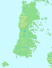
Español: Mapa en el dominio público English: PD map |
||||
| Author | Lin linao | ||||
| Permission (Reusing this file) |
|
File history
Click on a date/time to view the file as it appeared at that time.
| Date/Time | Thumbnail | Dimensions | User | Comment | |
|---|---|---|---|---|---|
| current | 19:15, 1 December 2011 | | 1,100 × 1,446 (1,017 KB) | Lin linao | Mejora de resolución y corrección de las bahías y fiordos que estaban marcados como cuerpos de agua interior. |
| 16:29, 5 September 2007 |  | 280 × 369 (21 KB) | Lin linao | {{Information |Description={{es|Mapa del Archipiélago de Chiloé (Chile)}} |Source= {{es|Mapa en el dominio público}}{{en|PD map}} |Date=5 de septiembre, 2007 |Author= Lin linao |Permission={{Demis |
File usage
The following pages on the English Wikipedia use this file (pages on other projects are not listed):
- Ancud
- Caicumeo
- Caleta Zorra
- Caucahue Island
- Caulín Bay
- Chacao, Chile
- Chacao Channel
- Chapalele
- Chilotan architecture
- Chilote School of Religious Imagery
- Chilote cap
- Chilote mythology
- Chilote poncho
- Chiloé Archipelago
- Chiloé Island
- Chiloé Wind Farm
- Church of Aldachildo
- Church of Caguach
- Church of Chelín
- Church of Chonchi
- Church of Colo
- Church of Detif
- Church of Ichuac
- Church of Nercón
- Church of Our Lady of Sorrows, Dalcahue
- Church of Quinchao
- Church of Rilán
- Church of San Francisco, Castro
- Church of San Juan Bautista, Dalcahue
- Church of Santa María de Loreto, Achao
- Church of Tenaún
- Church of Vilupulli
- Churches of Chiloé
- Circular Mission
- Cucao and Huillinco
- Cuisine of Chiloé
- Curanto
- Dalca
- Dalcahue Channel
- Desertores Islands
- Estero de Castro
- Governorate of Chiloé
- Guafo Island
- Gulf of Ancud
- Gulf of Corcovado
- Huilliche uprising of 1712
- Lemuy Island
- Licor de oro
- Natri Lake
- Potatoes of Chiloé
- Quemchi
- Quinchao
- Quinchao Island
- Red tide crisis in Chiloé
- Roca Remolinos
- San Pedro Island (Chile)
- San Pedro Wind Farm
- Sea of Chiloé
- Sirena chilota
- Tarahuín Lake
- Tepuhueico Lake
- Tranqui Island
- Trauco
- User:BuckskinBasher90/ChilotanSandbox
- User:Jmvgpartner/Test
- Template:Chiloe Archipelago
- Module:Location map/data/Chile Chiloé
- Module:Location map/data/Chile Chiloé/doc
- Module:Location map/data/Chiloé
Global file usage
The following other wikis use this file:
- Usage on ar.wikipedia.org
- قالب:Location map Chiloé
- كنائس تشيلوي
- كنيسة سانتا ماريا دي لوريتو (آتشاو)
- كنيسة كينتشاو
- كنيسة سان فرانثيسكو (كاسترو)
- كنيسة سانتا ماريا دي ريلان
- كنيسة سيدة جراثيا دي نيركون
- كنيسة آلداتشيلدو
- كنيسة إتشواك
- كنيسة ديتيف
- كنيسة بيلوبويي
- كنيسة تشونتشي
- كنيسة كولو
- كنيسة سان خوان باوتيستا (دالكاوي)
- كنيسة سيدة الأحزان (دالكاوي)
- كنيسة تشيلين
- كنيسة كاجواتش
- أرخبيل تشيلوي
- Usage on bg.wikipedia.org
- Usage on br.wikipedia.org
- Usage on ca.wikipedia.org
- Usage on ceb.wikipedia.org
- Usage on cs.wikipedia.org
- Usage on da.wikipedia.org
- Usage on de.wikipedia.org
- Usage on eo.wikipedia.org
- Usage on es.wikipedia.org
- Quellón
- Castro (Chile)
- Dalcahue
- Archipiélago de Chiloé
- Guafo
- Metalqui
- Isla Tac
- Achao
- Quíquel
- Conquista de Chiloé
- Chacao (Chile)
- Chulín (islas Desertores)
- Tenaún
- Aldachildo
- Detif
- Aeródromo Mocopulli
- Nercón
- Aeródromo Gamboa
- Aeródromo Pupelde
- Aeródromo Quellón
- Aeródromo Isla Apiao
- Aeródromo Butachauques
View more global usage of this file.