
Size of this PNG preview of this SVG file: 800 × 416 pixels. Other resolutions: 320 × 166 pixels | 640 × 333 pixels | 1,024 × 533 pixels | 1,280 × 666 pixels | 2,560 × 1,332 pixels | 1,440 × 749 pixels.
Original file (SVG file, nominally 1,440 × 749 pixels, file size: 625 KB)
| This is a file from the Wikimedia Commons. Information from its description page there is shown below. Commons is a freely licensed media file repository. You can help. |
Summary
| Description |
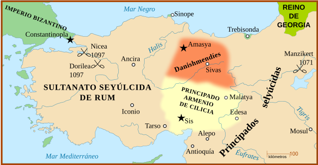
Español: Anatolia antes del sitio de Nicea de 1907 y con la localización de la batalla de Manzikert (1071).
English: A map of Anatolia before the Siege of Nicaea in 1097, also showing the location of the Battle of Manzikert, 1071. |
| Date | (UTC) |
| Source |
This file was derived from: Anatolia 1097.svg: |
| Author |
|
| Other versions |
[]
|


| This is a retouched picture, which means that it has been digitally altered from its original version. Modifications: translated into Spanish and text turned into real text (editable). The original can be viewed here: Anatolia 1097.svg:
|
Licensing
This file is licensed under the Creative Commons Attribution-Share Alike 3.0 Unported license.
- You are free:
- to share – to copy, distribute and transmit the work
- to remix – to adapt the work
- Under the following conditions:
- attribution – You must give appropriate credit, provide a link to the license, and indicate if changes were made. You may do so in any reasonable manner, but not in any way that suggests the licensor endorses you or your use.
- share alike – If you remix, transform, or build upon the material, you must distribute your contributions under the same or compatible license as the original.
Original upload log
This image is a derivative work of the following images:
- File:Anatolia_1097.svg licensed with Cc-by-sa-3.0,2.5,2.0,1.0, GFDL
- 2010-07-08T10:22:27Z Richardprins 1440x749 (530880 Bytes) Fixed trebizond typo
- 2008-02-27T03:22:25Z MapMaster 1440x749 (532613 Bytes) more fixes, + river names
- 2008-02-26T03:39:33Z MapMaster 1440x749 (532383 Bytes) Added Battle of Dorylaeum
- 2008-02-26T02:43:48Z MapMaster 1440x749 (498196 Bytes) minor edits
- 2008-02-26T00:36:50Z MapMaster 1440x749 (497714 Bytes) {{Information |Description=A map of [[w:en:Anatolia]] before the [[w:en:Siege of Nicaea|Siege of Nicaea]] in 1097. |Source=self-made |Date=25 February 2008 |Author= [[User:MapMaster|MapMaster]] |Permission= |other_versions= }
Uploaded with derivativeFX
File history
Click on a date/time to view the file as it appeared at that time.
| Date/Time | Thumbnail | Dimensions | User | Comment | |
|---|---|---|---|---|---|
| current | 11:24, 4 December 2019 | | 1,440 × 749 (625 KB) | Rowanwindwhistler | Minor changes |
| 12:02, 4 March 2016 |  | 1,440 × 749 (234 KB) | Rowanwindwhistler | 1907->1097 | |
| 14:46, 27 July 2015 |  | 1,440 × 749 (234 KB) | Rowanwindwhistler | Colours from http://colorbrewer2.org/ & https://en.wikipedia.org/wiki/Wikipedia:WikiProject_Maps/Conventions | |
| 08:51, 7 April 2013 |  | 1,440 × 749 (233 KB) | Rowanwindwhistler | == {{int:filedesc}} == {{Information |Description={{es|1=Anatolia antes del sitio de Nicea de 1907 y con la localización de la batalla de Manzikert (1071).}} {{en|1=A map of Anatolia before the [[w:en:Siege of Nicaea|Siege of Nicaea]... |
File usage
The following pages on the English Wikipedia use this file (pages on other projects are not listed):
Global file usage
The following other wikis use this file:
- Usage on es.wikipedia.org
- Usage on nl.wikipedia.org