Size of this preview: 755 × 600 pixels. Other resolutions: 302 × 240 pixels | 604 × 480 pixels | 778 × 618 pixels.
Original file (778 × 618 pixels, file size: 398 KB, MIME type: image/jpeg)
| This is a file from the Wikimedia Commons. Information from its description page there is shown below. Commons is a freely licensed media file repository. You can help. |
Summary
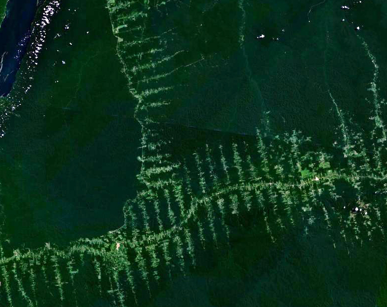
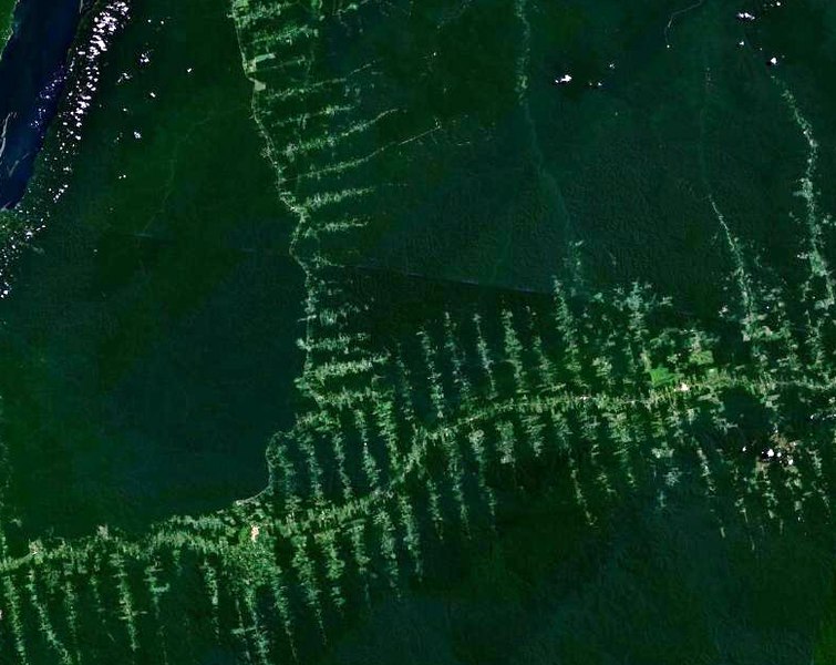
English: Deforestation in Amazonia, seen from satellite. The roads in the forest follow a typical "fish bone" pattern
Français : Déforestation en Amazonie, vu depuis un satellite. Les routes tracées dans la forêt suivent un motif caractéristique similaire à des arêtes de poisson
Deutsch: Entwaldung in Amazonien, aufgenommen vom Satelliten. Die in den Wald getriebenen Schneisen ergeben ein charakteristisches Fischgrätenmuster
Licensing
| This file is in the public domain in the United States because it was solely created by NASA. NASA copyright policy states that "NASA material is not protected by copyright unless noted". (See Template:PD-USGov, NASA copyright policy page or JPL Image Use Policy.) | ||
 |
Warnings:
|
File history
Click on a date/time to view the file as it appeared at that time.
| Date/Time | Thumbnail | Dimensions | User | Comment | |
|---|---|---|---|---|---|
| current | 20:02, 20 September 2006 | | 778 × 618 (398 KB) | Dake~commonswiki | {{en|Deforestation in Amazonia, seen from satellite. The roads in the forest follow a typical "fishbone" pattern}} {{fr|Déforestation en Amazonie, vu depuis un satellite. Les routes tracées dans la forêt suivent un motif caractéristique similaire à |
File usage
The following pages on the English Wikipedia use this file (pages on other projects are not listed):
Global file usage
The following other wikis use this file:
- Usage on ar.wikipedia.org
- Usage on bn.wikipedia.org
- Usage on ca.wikipedia.org
- Usage on chr.wikipedia.org
- Usage on de.wikipedia.org
- Usage on el.wikipedia.org
- Usage on eo.wikipedia.org
- Usage on es.wikipedia.org
- Usage on eu.wikipedia.org
- Usage on fr.wikipedia.org
- Usage on gu.wikipedia.org
- Usage on id.wikipedia.org
- Usage on ja.wikipedia.org
- Usage on nl.wikipedia.org
- Usage on pa.wikipedia.org
- Usage on pl.wikipedia.org
- Usage on pt.wikipedia.org
- Usage on ro.wikipedia.org
- Usage on ru.wikipedia.org
- Usage on sl.wikipedia.org
- Usage on sq.wikipedia.org
- Usage on ta.wikipedia.org
- Usage on tr.wikipedia.org
- Usage on vi.wikipedia.org