
Size of this PNG preview of this SVG file: 501 × 526 pixels. Other resolutions: 229 × 240 pixels | 457 × 480 pixels | 731 × 768 pixels | 975 × 1,024 pixels | 1,951 × 2,048 pixels.
Original file (SVG file, nominally 501 × 526 pixels, file size: 166 KB)
| This is a file from the Wikimedia Commons. Information from its description page there is shown below. Commons is a freely licensed media file repository. You can help. |
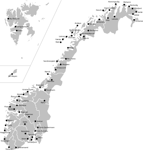
| Description | Map of Norway with all current and former public and military airports. This excludes private airports without scheduled services. Note: Svalbard and Jan Mayen are not to scale, and not geographically correctly located in relation to each other and mainland Norway. The accuracy of the map makes accurate placement of the airports sometimes a little off. |
| Date | (UTC) |
| Source | |
| Author |
|
This file is licensed under the Creative Commons Attribution-Share Alike 3.0 Unported license.
- You are free:
- to share – to copy, distribute and transmit the work
- to remix – to adapt the work
- Under the following conditions:
- attribution – You must give appropriate credit, provide a link to the license, and indicate if changes were made. You may do so in any reasonable manner, but not in any way that suggests the licensor endorses you or your use.
- share alike – If you remix, transform, or build upon the material, you must distribute your contributions under the same or compatible license as the original.
Original upload log
This image is a derivative work of the following images:
- File:Norway_counties_blank.svg licensed with Cc-by-sa-2.5
- 2008-07-16T09:52:07Z ZorroIII 256x256 (84546 Bytes) Correct county code for Telemark
- 2007-09-21T21:39:11Z Marmelad 256x256 (84546 Bytes) added information about regions
- 2007-09-21T21:24:01Z Marmelad 256x256 (84348 Bytes) forgot to remove example colouring
- 2007-09-21T21:23:01Z Marmelad 256x256 (84340 Bytes) {{Information |Description=Blank map of Norwegian counties, used e.g. to create locator maps. |Source=Based on [[:Image:Norway counties.svg]] |Date=2007-09-21 |Author=[[User:Marmelad|Marmelad]] |Permission= {{cc-by-sa-2.5}}
- File:Svalbard_outline.svg licensed with PD-self
- 2009-04-28T10:05:31Z Arsenikk 200x265 (39847 Bytes) {{Information |Description={{en|1=Vector outline map of Svalbard, Norway.}} |Source=Own work by uploader |Author=[[User:Arsenikk|Arsenikk]] |Date=2009-04-29 |Permission= |other_versions= }} [[Category:Maps of Svalbard]] [[C
- File:Jan_Mayen_outline.svg licensed with PD-self
- 2009-09-12T10:29:46Z Arsenikk 294x267 (8401 Bytes) {{Information |Description=Blank map of Jan Mayen (Norway) |Source=*[[:File:Jan_Mayen_blank.jpg|]] |Date=2009-09-12 10:28 (UTC) |Author=*[[:File:Jan_Mayen_blank.jpg|]]: Alfanje *derivative work: ~~~ |Permission=see below |oth
Uploaded with derivativeFX
File history
Click on a date/time to view the file as it appeared at that time.
| Date/Time | Thumbnail | Dimensions | User | Comment | |
|---|---|---|---|---|---|
| current | 11:23, 2 May 2021 | | 501 × 526 (166 KB) | BIL | I moved some airports slightly to reflect their actual position |
| 12:15, 12 September 2009 |  | 501 × 526 (170 KB) | Arsenikk | {{Information |Description=Map of Norway with all current and former public and military airports. This excludes private airports without scheduled services. Note: Svalbard and Jan Mayen are not to scale, and not geographically correctly located in relati |
File usage
The following pages on the English Wikipedia use this file (pages on other projects are not listed):
Global file usage
The following other wikis use this file:
- Usage on fa.wikipedia.org
- Usage on fr.wikipedia.org
- Usage on it.wikipedia.org
- Usage on no.wikipedia.org
- Usage on uk.wikipedia.org
- Usage on zh.wikipedia.org