Size of this preview: 785 × 600 pixels. Other resolutions: 314 × 240 pixels | 629 × 480 pixels | 1,006 × 768 pixels | 1,280 × 978 pixels | 2,560 × 1,955 pixels | 2,832 × 2,163 pixels.
Original file (2,832 × 2,163 pixels, file size: 6.82 MB, MIME type: image/jpeg)
| This is a file from the Wikimedia Commons. Information from its description page there is shown below. Commons is a freely licensed media file repository. You can help. |
Copied from the English Wikipedia. Original comment below:
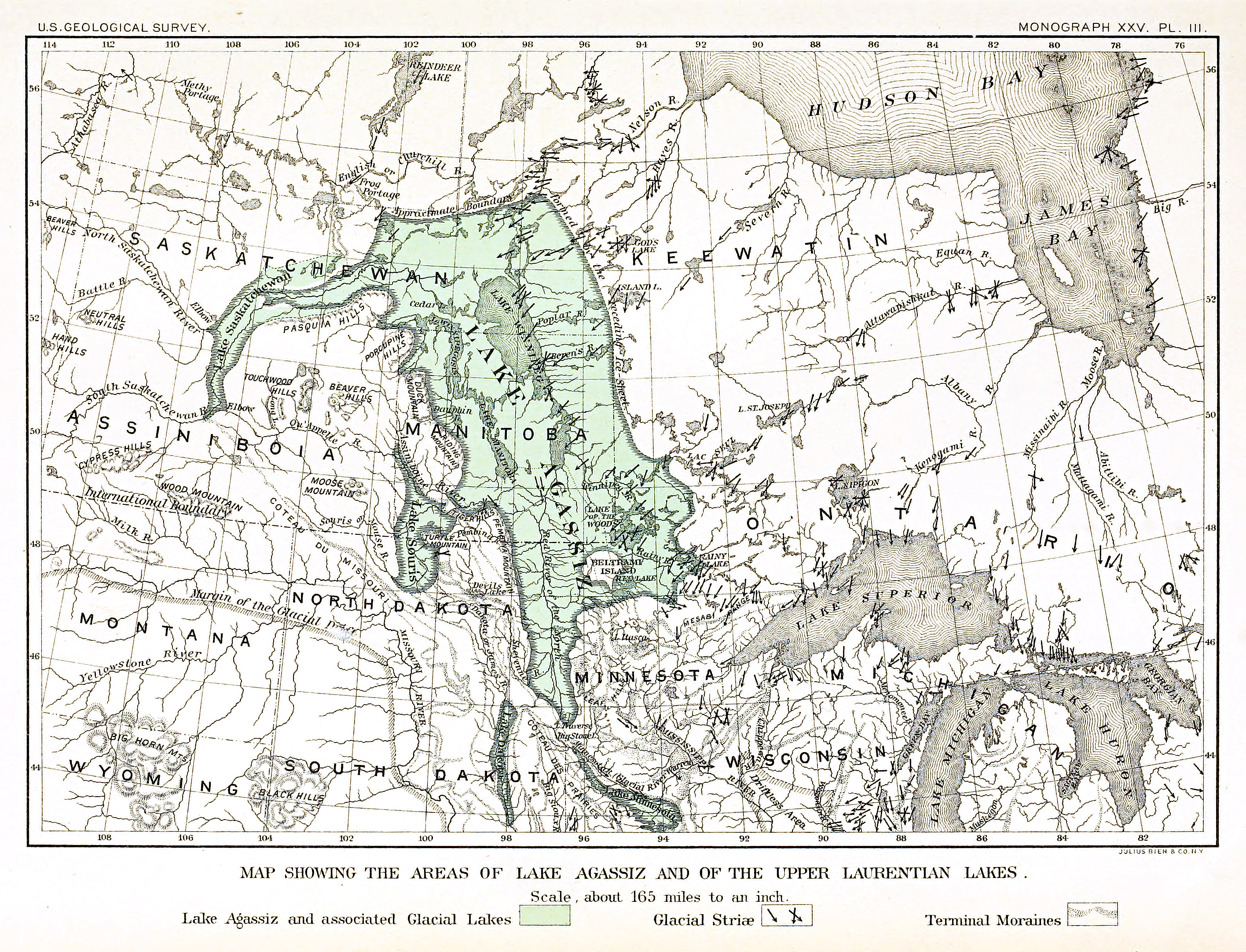
Map of the extent of glacial en:Lake Agassiz.
Bibliographical information: Upham, Warren. "The Glacial Lake Agassiz" archive copy at the Wayback Machine. Plate III. Monographs of the en:United States Geological Survey: Volume XXV. Washington Government Printing Office: Washington, 1895.
This image is in the public domain in the United States because it only contains materials that originally came from the United States Geological Survey, an agency of the United States Department of the Interior. For more information, see the official USGS copyright policy.
|
File history
Click on a date/time to view the file as it appeared at that time.
| Date/Time | Thumbnail | Dimensions | User | Comment | |
|---|---|---|---|---|---|
| current | 23:17, 13 August 2015 | | 2,832 × 2,163 (6.82 MB) | Themadchopper | larger etc. |
| 00:00, 8 September 2005 |  | 938 × 713 (309 KB) | L.m.k | Copied from the English Wikipedia. Original comment below: Map of the extent of glacial en:Lake Agassiz. Bibliographical information: Upham, Warren. [http://www.lib.ndsu.nodak.edu/govdocs/text/lakeagassiz/ "The Glacial Lake Agassiz"]. Plate III. M |
File usage
The following pages on the English Wikipedia use this file (pages on other projects are not listed):
Global file usage
The following other wikis use this file:
- Usage on ar.wikipedia.org
- Usage on be.wikipedia.org
- Usage on bg.wikipedia.org
- Usage on ca.wikipedia.org
- Usage on cs.wikipedia.org
- Usage on de.wikipedia.org
- Usage on eo.wikipedia.org
- Usage on es.wikipedia.org
- Usage on fi.wikipedia.org
- Usage on fr.wikipedia.org
- Usage on it.wikipedia.org
- Usage on ja.wikipedia.org
- Usage on ka.wikipedia.org
- Usage on lv.wikipedia.org
- Usage on ms.wikipedia.org
- Usage on nl.wikipedia.org
- Usage on nn.wikipedia.org
- Usage on no.wikipedia.org
- Usage on pl.wikipedia.org
- Usage on pt.wikipedia.org
- Usage on ru.wikipedia.org
- Usage on sh.wikipedia.org
- Usage on simple.wikipedia.org
- Usage on sk.wikipedia.org
- Usage on sl.wikipedia.org
- Usage on sq.wikipedia.org
- Usage on tr.wikipedia.org
- Usage on uk.wikipedia.org
- Usage on vi.wikipedia.org
- Usage on www.wikidata.org
- Usage on zh.wikipedia.org