
Size of this preview: 800 × 534 pixels. Other resolutions: 320 × 214 pixels | 640 × 427 pixels | 1,024 × 684 pixels | 1,280 × 855 pixels | 2,560 × 1,709 pixels | 7,968 × 5,320 pixels.
Original file (7,968 × 5,320 pixels, file size: 6.66 MB, MIME type: image/jpeg)
| This is a file from the Wikimedia Commons. Information from its description page there is shown below. Commons is a freely licensed media file repository. You can help. |
Summary
| Description |
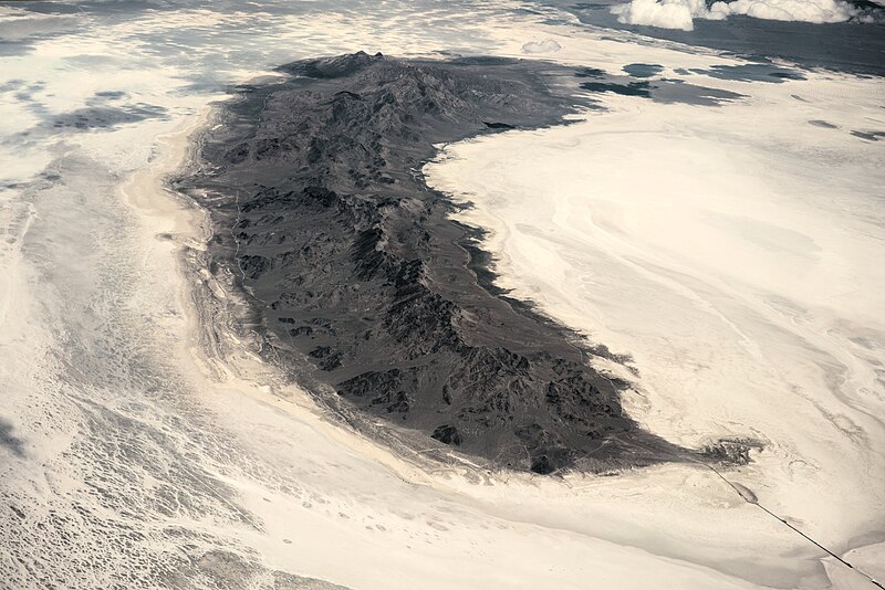
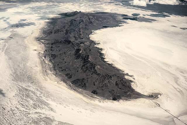
English: The Newfoundland Mountains in Utah is a mountain range located in Box Elder County. The highest point on this range is known as Desert Peak [1] (not to be confused with the Deseret Peak or the Desert Peak Formation, Nevada). This aerial photo was taken from a commercial flight from Salt Lake City to San Francisco. |
| Date | UTC (2018-06-18 11:57:11 local time) |
| Source | Own work |
| Author | Daniel L. Lu (user:dllu) |
| Raw file SHA1 sum | 06a40ffd75fa794b5ae497d8abfb0ea1e24563e2 |
| Camera location | | View this and other nearby images on: OpenStreetMap |
|---|
Licensing
I, the copyright holder of this work, hereby publish it under the following license:
This file is licensed under the Creative Commons Attribution-Share Alike 4.0 International license.
- You are free:
- to share – to copy, distribute and transmit the work
- to remix – to adapt the work
- Under the following conditions:
- attribution – You must give appropriate credit, provide a link to the license, and indicate if changes were made. You may do so in any reasonable manner, but not in any way that suggests the licensor endorses you or your use.
- share alike – If you remix, transform, or build upon the material, you must distribute your contributions under the same or compatible license as the original.
This image has been assessed using the Quality image guidelines and is considered a Quality image.
|

|
This image has been assessed under the valued image criteria and is considered the most valued image on Commons within the scope: Aerial photographs of the Newfoundland Mountains. You can see its nomination here. |
File history
Click on a date/time to view the file as it appeared at that time.
| Date/Time | Thumbnail | Dimensions | User | Comment | |
|---|---|---|---|---|---|
| current | 18:55, 19 June 2018 | | 7,968 × 5,320 (6.66 MB) | Dllu | =={{int:filedesc}}== {{Information |description = {{en|1 = The Desert Peak Formation is a geologic formation in Nevada. It preserves fossils dating to the Neogene period. This aerial photo was taken from a commercial flight from Salt Lake City to San Francisco.}} |date = 2018-06-18 17:57:11 UTC (2018-06-18 11:57:11 local time) |source = {{own}} |author = Daniel L. Lu (user:dllu) |other fields = {{Information field | name =... |
File usage
The following pages on the English Wikipedia use this file (pages on other projects are not listed):
Global file usage
The following other wikis use this file:
- Usage on arz.wikipedia.org
- Usage on ceb.wikipedia.org
- Usage on www.wikidata.org