No higher resolution available.
Aeolis_Mensae_Yardangs.JPG (620 × 464 pixels, file size: 74 KB, MIME type: image/jpeg)
| This is a file from the Wikimedia Commons. Information from its description page there is shown below. Commons is a freely licensed media file repository. You can help. |

|
This file was moved to Wikimedia Commons from en.wikipedia using a bot script. All source information is still present. It requires review. Additionally, there may be errors in any or all of the information fields; information on this file should not be considered reliable and the file should not be used until it has been reviewed and any needed corrections have been made. Once the review has been completed, this template should be removed. For details about this file, see below. Check now! |
Summary
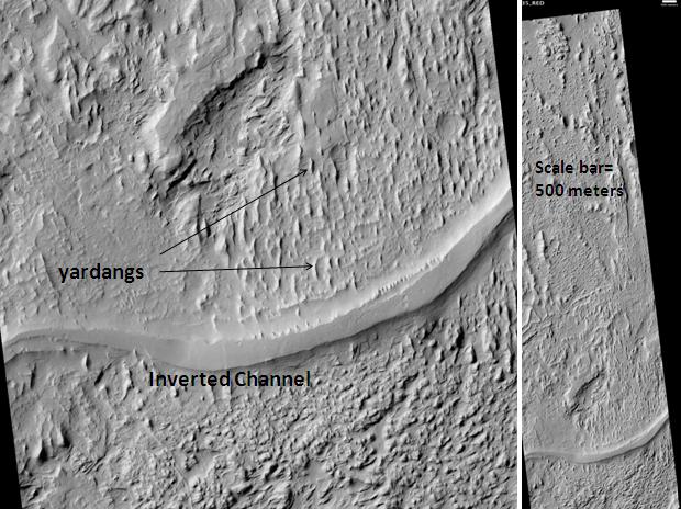
| Description | Aeolis Mensae Yardangs and inverted channel, as seen by hirise. Location is 6.3 degrees south latitude and 151.1 degrees east longitude. Image was taken by the Mars Reconnaissance Orbiter's HiRISE. The HiRISE camera was built by Ball Aerospace and Technology Corporation and is operated by the University of Arizona. Image courtesy NASA/JPL/University of Arizona. |
| Date | |
| Source | http://hirise.lpl.arizona.edu/PSP_009966_1735 |
| Author | Jim Secosky modified nasa image. |
Licensing
| This file is in the public domain in the United States because it was solely created by NASA. NASA copyright policy states that "NASA material is not protected by copyright unless noted". (See Template:PD-USGov, NASA copyright policy page or JPL Image Use Policy.) | ||
 |
Warnings:
|
File history
Click on a date/time to view the file as it appeared at that time.
| Date/Time | Thumbnail | Dimensions | User | Comment | |
|---|---|---|---|---|---|
| current | 04:35, 21 March 2010 | | 620 × 464 (74 KB) | Ohms Law Bot | {{BotMoveToCommons|1=en.wikipedia|day=21|month=March|year=2010}} == Summary == {{Information |Description = Aeolis Mensae Yardangs and inverted channel, as seen by hirise. Location is 6.3 degrees south latitude and 151.1 degrees east longitude. Ima |
File usage
The following pages on the English Wikipedia use this file (pages on other projects are not listed):
Global file usage
The following other wikis use this file:
- Usage on fr.wikipedia.org
- Usage on pt.wikipedia.org
- Usage on uk.wikipedia.org
- Usage on zh.wikipedia.org