
Size of this preview: 440 × 599 pixels. Other resolutions: 176 × 240 pixels | 353 × 480 pixels | 564 × 768 pixels | 752 × 1,024 pixels | 1,505 × 2,048 pixels | 8,141 × 11,078 pixels.
Original file (8,141 × 11,078 pixels, file size: 26.86 MB, MIME type: image/jpeg)
| This is a file from the Wikimedia Commons. Information from its description page there is shown below. Commons is a freely licensed media file repository. You can help. |
Summary
| Warning | The original file is very high-resolution. It might not load properly or could cause your browser to freeze when opened at full size. |
|---|
| Description |
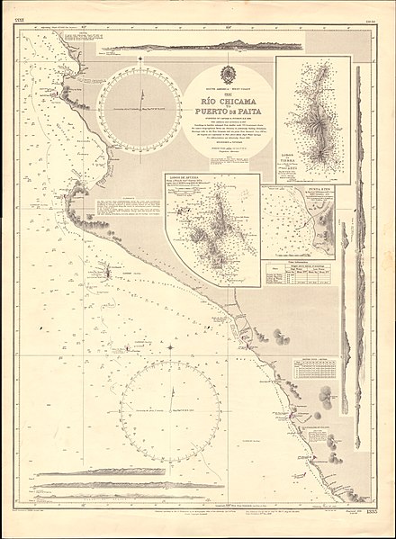
English: Nautical chart of the coast of Peru from Rio Chicama to Puerto de Paita, at a scale of 1:585,000. Surveyed by Captain R. Fitzroy, 1836. Not current - not to be used for navigation! |
||||||||||
| Date | |||||||||||
| Source | Scan of original Admiralty Chart | ||||||||||
| Author |
|
||||||||||
| Other versions | |||||||||||
.jpg)
Licensing
This work created by the United Kingdom Government is in the public domain.
This is because it is one of the following:
HMSO has declared that the expiry of Crown Copyrights applies worldwide (ref: HMSO Email Reply)
|
 |
File history
Click on a date/time to view the file as it appeared at that time.
| Date/Time | Thumbnail | Dimensions | User | Comment | |
|---|---|---|---|---|---|
| current | 07:51, 18 September 2020 | | 8,141 × 11,078 (26.86 MB) | Kognos | Reverted to version as of 09:38, 16 September 2020 (UTC) |
| 07:44, 18 September 2020 |  | 1,137 × 857 (491 KB) | Kognos | Cropped 86 % horizontally, 92 % vertically using CropTool with lossless mode. | |
| 09:38, 16 September 2020 |  | 8,141 × 11,078 (26.86 MB) | Kognos | Uploaded a work by Hydrographic Office of the Admiralty from Scan of original Admiralty Chart with UploadWizard |
File usage
No pages on the English Wikipedia use this file (pages on other projects are not listed).
Global file usage
The following other wikis use this file:
- Usage on fr.wikipedia.org