
Size of this preview: 800 × 600 pixels. Other resolutions: 320 × 240 pixels | 640 × 480 pixels | 1,024 × 768 pixels | 1,280 × 960 pixels | 2,592 × 1,944 pixels.
Original file (2,592 × 1,944 pixels, file size: 1.63 MB, MIME type: image/jpeg)
| This is a file from the Wikimedia Commons. Information from its description page there is shown below. Commons is a freely licensed media file repository. You can help. |
Summary
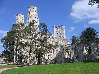
| Description | Abbaye de Jumièges, Seine-Maritime, Haute-Normandie, France |
| Date | |
| Source | Own work |
| Author | Franz Golhen |
| Object location | | View this and other nearby images on: OpenStreetMap |
|---|
Licensing
| I, the copyright holder of this work, release this work into the public domain. This applies worldwide. In some countries this may not be legally possible; if so: I grant anyone the right to use this work for any purpose, without any conditions, unless such conditions are required by law. |
File history
Click on a date/time to view the file as it appeared at that time.
| Date/Time | Thumbnail | Dimensions | User | Comment | |
|---|---|---|---|---|---|
| current | 19:04, 15 September 2007 | | 2,592 × 1,944 (1.63 MB) | Golhen | {{Information |Description= Abbaye de Jumièges, Seine-Maritime, Haute-Normandie, France |Source=travail personnel |Date= 09/2007 |Author= Franz Golhen }} |
File usage
The following pages on the English Wikipedia use this file (pages on other projects are not listed):
Global file usage
The following other wikis use this file:
- Usage on be.wikipedia.org
- Usage on eo.wikipedia.org
- Usage on es.wikipedia.org
- Usage on fr.wikipedia.org
- Architecture romane
- Robert de Jumièges
- Liste d'abbayes bénédictines de France
- Abbaye de Jumièges
- Liste des monuments historiques de l'arrondissement de Rouen
- Liste des monuments historiques protégés en 1918
- Liste des monuments historiques protégés en 1921
- Liste des monuments historiques protégés en 1947
- Usage on hu.wikipedia.org
- Usage on it.wikipedia.org
- Usage on nl.wikipedia.org
- Usage on no.wikipedia.org
- Usage on nrm.wikipedia.org
- Usage on pl.wikipedia.org
- Usage on pt.wikipedia.org
- Usage on ro.wikipedia.org
- Usage on sh.wikipedia.org
- Usage on sl.wikipedia.org
- Usage on www.wikidata.org