
Size of this preview: 800 × 566 pixels. Other resolutions: 320 × 226 pixels | 640 × 453 pixels | 1,024 × 724 pixels | 1,410 × 997 pixels.
Original file (1,410 × 997 pixels, file size: 136 KB, MIME type: image/jpeg)
| This is a file from the Wikimedia Commons. Information from its description page there is shown below. Commons is a freely licensed media file repository. You can help. |
Summary
| Description |
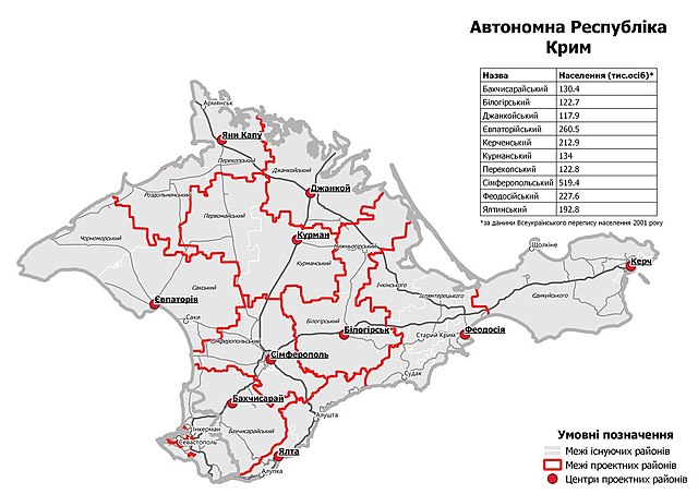
English: Subdivisions of the Autonomous Republic of Crimea, as adopted by the Verkhovna Rada on 17 July 2020. Work of the Ministry of Territorial Development, available as CC-BY 4.0. Raion borders and centers are shown in red, borders of united territorial communities are shown in white. As Ukraine does not control Crimea, the divisions have not been implemented and only exist on paper. |
| Date | |
| Source | https://www.minregion.gov.ua/press/news/novi-rajony-karty-sklad/ |
| Author | Ministry of Territorial Development, Ukraine |
Licensing
This file is licensed under the Creative Commons Attribution 4.0 International license.
- You are free:
- to share – to copy, distribute and transmit the work
- to remix – to adapt the work
- Under the following conditions:
- attribution – You must give appropriate credit, provide a link to the license, and indicate if changes were made. You may do so in any reasonable manner, but not in any way that suggests the licensor endorses you or your use.
File history
Click on a date/time to view the file as it appeared at that time.
| Date/Time | Thumbnail | Dimensions | User | Comment | |
|---|---|---|---|---|---|
| current | 17:35, 4 October 2020 | | 1,410 × 997 (136 KB) | Ymblanter | Uploaded a work by Ministry of Territorial Development, Ukraine from https://www.minregion.gov.ua/press/news/novi-rajony-karty-sklad/ with UploadWizard |
File usage
The following pages on the English Wikipedia use this file (pages on other projects are not listed):
- Administrative divisions of Crimea
- Alushta Municipality
- Armiansk Municipality
- Bakhchysarai Raion
- Bilohirsk Raion
- Chornomorske Raion
- Dzhankoi Raion
- Feodosia Municipality
- Kirovske Raion
- Krasnohvardiiske Raion
- Krasnoperekopsk Raion
- Lenine Raion
- Nyzhnohirskyi Raion
- Pervomaiske Raion
- Rozdolne Raion
- Saky Municipality
- Saky Raion
- Simferopol Municipality
- Simferopol Raion
- Sovietskyi Raion
- Sudak Municipality
- Yalta Municipality
- Yevpatoria Municipality
Global file usage
The following other wikis use this file:
- Usage on ko.wikipedia.org
- Usage on ro.wikipedia.org
- Usage on zh.wikipedia.org