Size of this preview: 748 × 600 pixels. Other resolutions: 299 × 240 pixels | 599 × 480 pixels | 958 × 768 pixels | 1,277 × 1,024 pixels | 2,400 × 1,925 pixels.
Original file (2,400 × 1,925 pixels, file size: 954 KB, MIME type: image/jpeg)
| This is a file from the Wikimedia Commons. Information from its description page there is shown below. Commons is a freely licensed media file repository. You can help. |
Summary
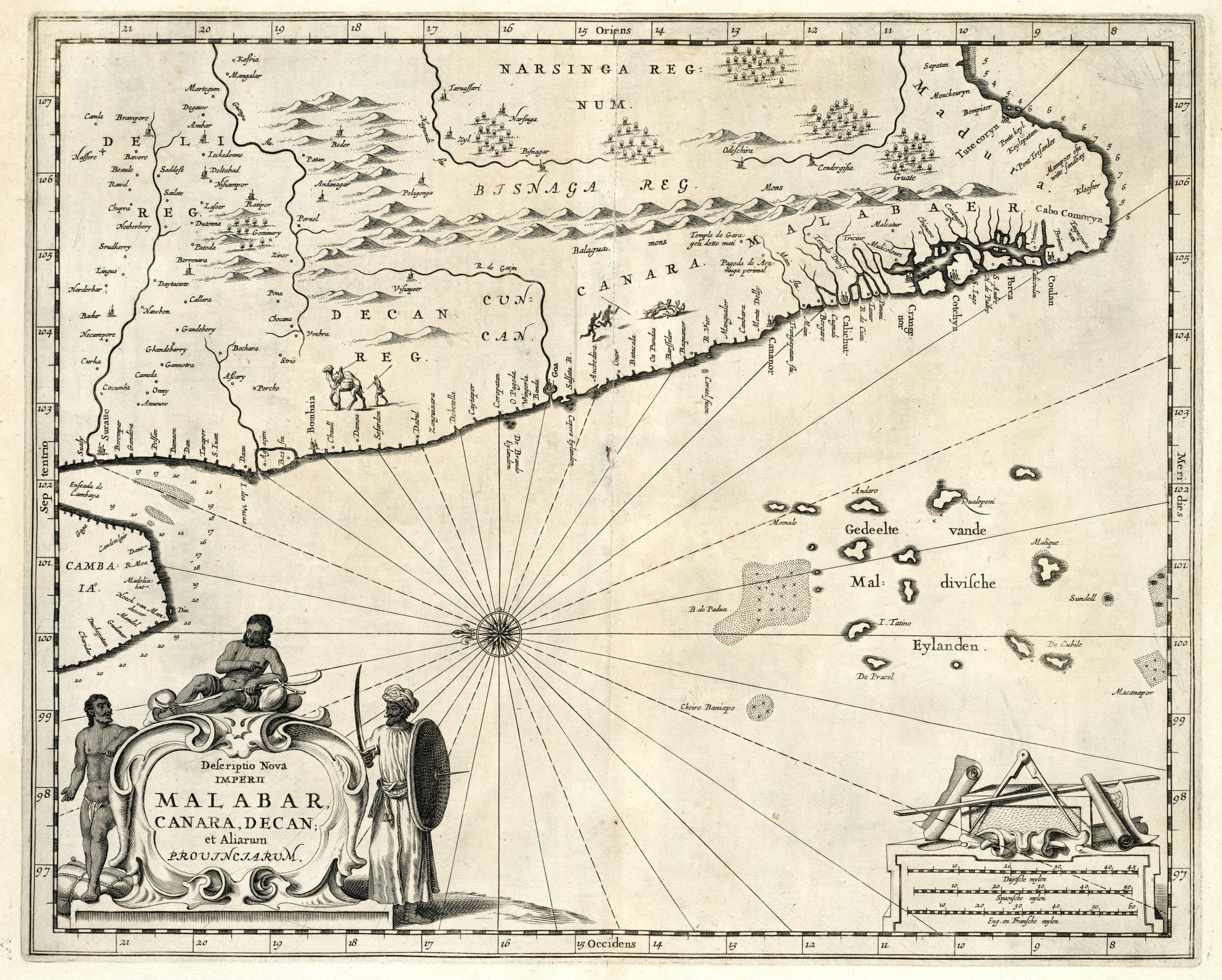
Nederlands: Kaart van de Malabarkust
English: Map of the Malabar Coast( |
|||||||||||||||||||||
|---|---|---|---|---|---|---|---|---|---|---|---|---|---|---|---|---|---|---|---|---|---|
| Author |
Creator:Johannes Janssonius Waasbergen Nederlands: Anoniem / Anonymous (landmeter / kaartenmaker), Johannes Janssonius Waasbergen (uitgever)
English: Anoniem / Anonymous (land surveyor / mapmaker), Johannes Janssonius Waasbergen (publisher) |
||||||||||||||||||||
| Title |
Nederlands: Kaart van de Malabarkust
English: Map of the Malabar Coast |
||||||||||||||||||||
| Description |
Nederlands: Kaart van de Malabarkust.
Descriptio Nova Imperii Malabar Canara, Decan, et Aliarum Provinciarum. In de kaart zijn enkele mensen en dieren ingetekend.English: Map of the Malabar Coast.
Descriptio Nova Imperii Malabar Canara, Decan, et Aliarum Provinciarum. The chart features several figures and animals. |
||||||||||||||||||||
| Date | circa 1672 | ||||||||||||||||||||
| Medium |
Nederlands: koperdruk op papier
English: copperplate printing on paper |
||||||||||||||||||||
| Dimensions | height: 38 cm (14.9 in); width: 30 cm (11.8 in) | ||||||||||||||||||||
| Collection |
|
||||||||||||||||||||
| Accession number |
189 A 6 deel I, voor p. 1 |
||||||||||||||||||||
| Inscriptions |
Descriptio Nova Imperii Malabar Canara, Decan, et Aliarum Provinciarum
|
||||||||||||||||||||
| Notes |
English: Subjects: chart / map / plan, banderole / cartouche / ornamentation, compass / dial, fauna, Person
Nederlands: Onderwerpen: plattegrond / kaart, banderol / cartouche / versiering, kompas / windroos, fauna, Persoon
English: Post: this image is related to a VOC trading post called Surat |
||||||||||||||||||||
| Source/Photographer |
|
||||||||||||||||||||
| Permission (Reusing this file) |
|
||||||||||||||||||||

| Object location | | View this and other nearby images on: OpenStreetMap |
|---|
File history
Click on a date/time to view the file as it appeared at that time.
| Date/Time | Thumbnail | Dimensions | User | Comment | |
|---|---|---|---|---|---|
| current | 11:54, 10 June 2014 | | 2,400 × 1,925 (954 KB) | HuskyBot | == {{int:filedesc}} == {{Artwork |title = {{nl|1=Kaart van de Malabarkust}} {{en|1=Map of the Malabar Coast}} |description = {{nl|1=Kaart van de Malabarkust. ''Descriptio Nova Imperii Malabar Canara, Decan, et... |
File usage
The following pages on the English Wikipedia use this file (pages on other projects are not listed):
Global file usage
The following other wikis use this file:
- Usage on ar.wikipedia.org