
Original file (2,400 × 1,730 pixels, file size: 505 KB, MIME type: image/jpeg)
| This is a file from the Wikimedia Commons. Information from its description page there is shown below. Commons is a freely licensed media file repository. You can help. |
Summary
Nederlands: Plattegrond van het fort te Jaffanapatnam
English: Map of the fort at Jaffanapatnam( |
||||||||||||||||||||||||
|---|---|---|---|---|---|---|---|---|---|---|---|---|---|---|---|---|---|---|---|---|---|---|---|---|
| Author |
Nederlands: Anoniem / Anonymous
English: Anoniem / Anonymous |
|||||||||||||||||||||||
| Title |
Nederlands: Plattegrond van het fort te Jaffanapatnam
English: Map of the fort at Jaffanapatnam |
|||||||||||||||||||||||
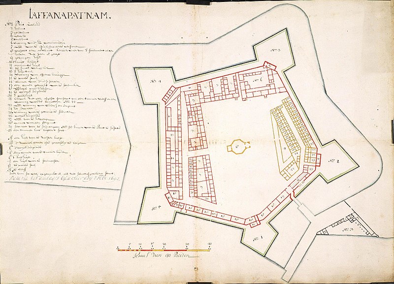
| Description |
Nederlands: Titel catalogus Leupe (NA): Platte grond van het Kasteel te Jaffanapatnam.
Plattegrond van de vesting te Jaffanapatnam, met bouw van een woning voor de timmerman; In zwart zijn de werken aangegeven die gebouwd zijn in 1693; in geel de geplande bouw van timmermanswoning. Notities verso: Kaart van het Casteel tot J [...] nr. 2. [Gedrukt etiket] nr. 545..English: According to the Leupe catalogue (NA), the original title reads: Platte grond van het Kasteel te Jaffanapatnam.
Map of the fort at Jaffanapatnam, with buildings and a house for the carpenter. The buildings constructed in 1693 are indicated in black, while the planned house for the carpenter is shown in yellow. Notes on reverse: Kaart van het Casteel tot J [...] nr. 2. [Printed label] nr. 545.. |
|||||||||||||||||||||||
| Date | 3 February 1693 | |||||||||||||||||||||||
| Medium |
Nederlands: ingekleurde tekening op papier
English: coloured drawing on paper |
|||||||||||||||||||||||
| Dimensions | height: 71 cm (27.9 in); width: 51 cm (20 in) | |||||||||||||||||||||||
| Collection |
|
|||||||||||||||||||||||
| Accession number |
NL-HaNA_4.VEL_998 (old number: VEL0998) |
|||||||||||||||||||||||
| Inscriptions |
Jaffanapatnam
|
|||||||||||||||||||||||
| Notes |
English: Subjects: factory / workshop, fortification, key, chart / map / plan
Nederlands: Onderwerpen: fabriek / werkplaats, vesting, legenda, plattegrond / kaart
English: Post: this image is related to a VOC trading post called Jaffna |
|||||||||||||||||||||||
| Source/Photographer |
|
|||||||||||||||||||||||
| Permission (Reusing this file) |
|
|||||||||||||||||||||||

| Object location | | View this and other nearby images on: OpenStreetMap |
|---|
File history
Click on a date/time to view the file as it appeared at that time.
| Date/Time | Thumbnail | Dimensions | User | Comment | |
|---|---|---|---|---|---|
| current | 16:24, 10 June 2014 | | 2,400 × 1,730 (505 KB) | HuskyBot | == {{int:filedesc}} == {{Artwork |title = {{nl|1=Plattegrond van het fort te Jaffanapatnam}} {{en|1=Map of the fort at Jaffanapatnam}} |description = {{nl|1=Titel catalogus Leupe (NA): ''Platte grond van het Ka... |
File usage
Global file usage
The following other wikis use this file:
- Usage on fr.wikipedia.org
- Usage on ja.wikipedia.org
- Usage on my.wikipedia.org