Size of this preview: 800 × 588 pixels. Other resolutions: 320 × 235 pixels | 640 × 471 pixels | 850 × 625 pixels.
Original file (850 × 625 pixels, file size: 133 KB, MIME type: image/jpeg)
| This is a file from the Wikimedia Commons. Information from its description page there is shown below. Commons is a freely licensed media file repository. You can help. |
Summary
| Description |
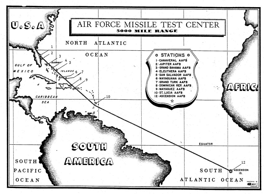
English: Air Force Eastern Test Range of 1957 In October 1952, the Air Research and Development Command approved a plan to extend the Eastern Range's length to 5,000 miles to meet SNARK and NAVAHO missile testing requirements. Antigua, St. Lucia, Fernando de Noronha and Ascension were tentatively selected as host sites, and agree-ments were negotiated with the governments of Britain, St. Lucia, Brazil and Ascension to authorize construction. The St. Lucia and Ascension agree-ments were signed on 26 June 1956, and the Brazilian Agreement was signed on 21 January 1957. Following an exchange of notes with the State Department, Britain granted the U.S. access to Antigua on 15 January 1957. The St. Lucia site was activated on 5 December 1956, and Antigua and Ascension were ready for operations in October 1957. The Fernando de Noronha station was activated off the coast of Brazil on 18 September 1958. Twelve small telemetry ships were positioned downrange to fill in the gaps between Antigua and Ascension in 1957 and 1958.** The Eastern Range supported its first 5,000-mile-long mission (a SNARK test flight) on 31 October 1957. |
| Date | |
| Source | http://www.patrick.af.mil/art/; https://web.archive.org/web/20100831073702/http://www.patrick.af.mil/art/mediagallery.asp?galleryID=2102 |
| Author | U.S. Air Force |

|
This image was released by the United States Air Force with the ID AFG-060829-002 (next).
|
|
|
This image was released by the United States Air Force with the ID 060829-F-JZ506-288 (next).
|
Licensing
This image or file is a work of a U.S. Air Force Airman or employee, taken or made as part of that person's official duties. As a work of the U.S. federal government, the image or file is in the public domain in the United States.
|
 |
File history
Click on a date/time to view the file as it appeared at that time.
| Date/Time | Thumbnail | Dimensions | User | Comment | |
|---|---|---|---|---|---|
| current | 07:08, 10 October 2007 | | 850 × 625 (133 KB) | CarolSpears | {{Information |Description=Air Force Eastern Test Range of 1957. |Source=http://www.patrick.af.mil/art/ |Date=1957 |Author=http://www.af.mil/ USAF |Permission={{PD-USGov-Military-Air Force}} |other_versions= }} Category:Atlantic Missile Range [[Ca |
File usage
The following pages on the English Wikipedia use this file (pages on other projects are not listed):
Global file usage
The following other wikis use this file:
- Usage on ar.wikipedia.org
- Usage on ja.wikipedia.org
- Usage on sk.wikipedia.org
- Usage on www.wikidata.org