Size of this preview: 800 × 580 pixels. Other resolutions: 320 × 232 pixels | 640 × 464 pixels | 1,024 × 743 pixels | 1,280 × 928 pixels | 2,551 × 1,850 pixels.
Original file (2,551 × 1,850 pixels, file size: 793 KB, MIME type: image/png)
| This is a file from the Wikimedia Commons. Information from its description page there is shown below. Commons is a freely licensed media file repository. You can help. |
Summary
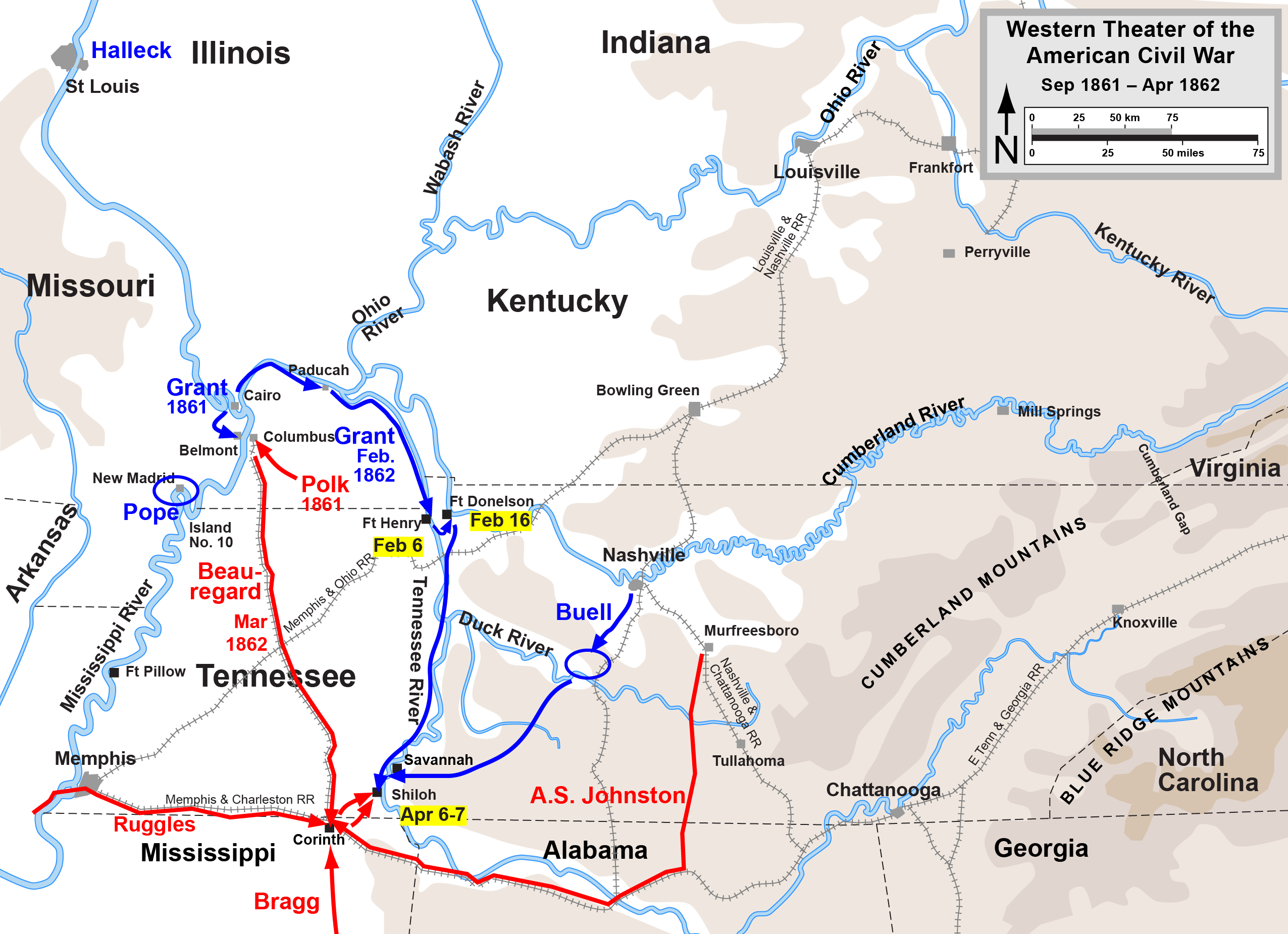
| Description | Map of the en:Western Theater of the American Civil War, actions from Belmont to Shiloh. Drawn by Hal Jespersen in Adobe Illustrator CS5. Graphic source file is available at http://www.posix.com/CWmaps/ |
| Date | 31 March 2006 (original upload date) |
| Source | Transferred from en.wikipedia to Commons. |
| Author | The original uploader was Hlj at English Wikipedia. |
Licensing
This file is licensed under the Creative Commons Attribution 3.0 Unported license.
Attribution: Map by Hal Jespersen, www.posix.com/CW
- You are free:
- to share – to copy, distribute and transmit the work
- to remix – to adapt the work
- Under the following conditions:
- attribution – You must give appropriate credit, provide a link to the license, and indicate if changes were made. You may do so in any reasonable manner, but not in any way that suggests the licensor endorses you or your use.
Original upload log
The original description page was here. All following user names refer to en.wikipedia.
- 2006-03-31 00:30 Hlj 2455×1844×8 (795368 bytes) Map of the [[Western Theater of the American Civil War]], actions from Belmont to Shiloh. Drawn by Hal Jespersen in Macromedia Freehand. Graphic source file is available at http://www.posix.com/CWmaps/ {{PD-release}}
File history
Click on a date/time to view the file as it appeared at that time.
| Date/Time | Thumbnail | Dimensions | User | Comment | |
|---|---|---|---|---|---|
| current | 20:46, 24 March 2011 | | 2,551 × 1,850 (793 KB) | Hlj | Update graphical style of rivers. Same license. |
| 16:44, 28 May 2010 |  | 2,551 × 1,850 (648 KB) | Hlj | Cleaned up some graphics, added legend and scale. {{cc-by-3.0|Map by Hal Jespersen, www.posix.com/CW}} Category:American Civil War | |
| 16:13, 24 May 2009 |  | 2,572 × 1,862 (584 KB) | Hlj | Location tweaks (didn't take in previous update). {{cc-by-3.0|Map by Hal Jespersen, www.posix.com/CW}} | |
| 16:10, 24 May 2009 |  | 2,572 × 1,862 (584 KB) | Hlj | Location tweaks. {{cc-by-3.0|Map by Hal Jespersen, www.posix.com/CW}} | |
| 16:04, 24 May 2009 |  | 2,572 × 1,862 (584 KB) | Hlj | A few more labels. {{cc-by-3.0|Map by Hal Jespersen, www.posix.com/CW}} | |
| 15:34, 24 May 2009 |  | 2,572 × 1,862 (578 KB) | Hlj | Added some geographic labels. {{cc-by-3.0|Map by Hal Jespersen, www.posix.com/CW}} | |
| 17:16, 7 December 2007 |  | 2,572 × 1,862 (560 KB) | Hlj | {{Information |Description= American Civil War map of the western theater (modified to include Mills Springs) |Source=self-made |Date= December 7, 2007 |Author= Hlj |Permission= |other_versions= }} | |
| 13:53, 30 March 2007 |  | 2,455 × 1,844 (777 KB) | Angusmclellan | {{Information |Description=Map of the en:Western Theater of the American Civil War, actions from Belmont to Shiloh. Drawn by Hal Jespersen in Macromedia Freehand. Graphic source file is available at http://www.posix.com/CWmaps/ |Source=Originally fro |
File usage
No pages on the English Wikipedia use this file (pages on other projects are not listed).
Global file usage
The following other wikis use this file:
- Usage on da.wikipedia.org
- Usage on it.wikipedia.org
- Usage on ja.wikipedia.org
- Usage on mn.wikipedia.org
- Usage on nl.wikipedia.org
- Usage on no.wikipedia.org