No higher resolution available.
AASHO_Road_Test_-_Areal_View.png (431 × 366 pixels, file size: 274 KB, MIME type: image/png)
| This is a file from the Wikimedia Commons. Information from its description page there is shown below. Commons is a freely licensed media file repository. You can help. |
Summary
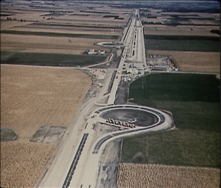
| Description |
Deutsch: Überblick über die Teststrecke des AASHO Road Test Areal nach Abschluss der Versuche |
| Date | |
| Source | https://www.fhwa.dot.gov/highwayhistory/ |
| Author | US Federal Highway Administration |
Licensing
| This image is a work of a United States Department of Transportation employee, taken or made as part of that person's official duties. As a work of the U.S. federal government, the image is in the public domain.
|
File history
Click on a date/time to view the file as it appeared at that time.
| Date/Time | Thumbnail | Dimensions | User | Comment | |
|---|---|---|---|---|---|
| current | 08:26, 12 August 2020 | | 431 × 366 (274 KB) | BlaeX | cropped |
| 15:15, 11 August 2020 |  | 512 × 441 (327 KB) | BlaeX | Uploaded a work by US Federal Highway Administration from https://www.fhwa.dot.gov/highwayhistory/ with UploadWizard |
File usage
The following pages on the English Wikipedia use this file (pages on other projects are not listed):
Global file usage
The following other wikis use this file:
- Usage on de.wikipedia.org
- Usage on es.wikipedia.org
- Usage on uk.wikipedia.org