
Size of this preview: 454 × 599 pixels. Other resolutions: 182 × 240 pixels | 364 × 480 pixels | 1,000 × 1,319 pixels.
Original file (1,000 × 1,319 pixels, file size: 246 KB, MIME type: image/jpeg)
| This is a file from the Wikimedia Commons. Information from its description page there is shown below. Commons is a freely licensed media file repository. You can help. |
Summary
| Description |
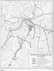
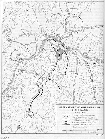
English: Map of the US 34th Infantry Regiment's defense at the Kum River, July 14, 1950 |
| Date | |
| Source | http://www.koreanwar.org/html/maps_cmh.html, map as originally published in South to the Naktong, North to the Yalu by Roy Appleman, US Army historian (1992) |
| Author | Center of Military History, United States Army |
| Other versions |
 (colored map) (colored map) |
Licensing
This file is a work of a U.S. Army soldier or employee, taken or made as part of that person's official duties. As a work of the U.S. federal government, it is in the public domain in the United States.
|
 |
File history
Click on a date/time to view the file as it appeared at that time.
| Date/Time | Thumbnail | Dimensions | User | Comment | |
|---|---|---|---|---|---|
| current | 00:22, 17 March 2010 | | 1,000 × 1,319 (246 KB) | Jim101 | {{Information |Description={{en|1=Map of the US 34th Infantry Regiment's defense at the Kum River, July 14, 1950}} |Source=http://www.koreanwar.org/html/maps_cmh.html |Author=Center of Military History, United States Army |Date=1961 |Permission= |other_ve |
File usage
No pages on the English Wikipedia use this file (pages on other projects are not listed).