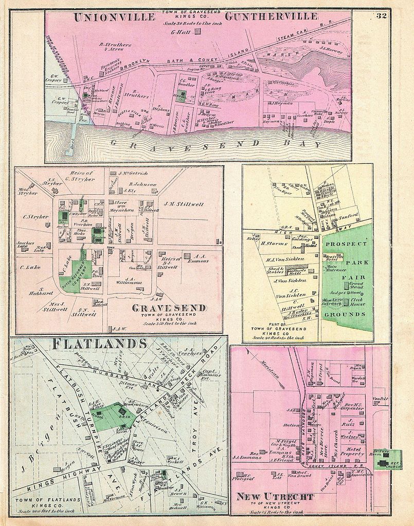
File:1873 Beers Map of Gravesend, Flatlands, New Utrecht and Unionville, Brooklyn, New York City - Geographicus - UnionvilleGuntherville-beers-1873.jpg

Original file (2,359 × 3,000 pixels, file size: 2.04 MB, MIME type: image/jpeg)
| This is a file from the Wikimedia Commons. Information from its description page there is shown below. Commons is a freely licensed media file repository. You can help. |
| Unionville Guntherville, Town of Gravesend, Kings Co. - Gravesend, Town of Gravesend, Kings Co. - Part of Town of Gravesend, Kings Co. - Flatlands, Town of Flatlands, Kings Co.- New Utrecht, Tn of New Utrecht, Kings Co. | ||||||
|---|---|---|---|---|---|---|
| Artist | ||||||
| Title |
Unionville Guntherville, Town of Gravesend, Kings Co. - Gravesend, Town of Gravesend, Kings Co. - Part of Town of Gravesend, Kings Co. - Flatlands, Town of Flatlands, Kings Co.- New Utrecht, Tn of New Utrecht, Kings Co. |
|||||
| Description |
English: A scarce example of Fredrick W. Beers’ map of the communities of Unionville, Guntherville, Gravesend, Flatlands and New Utrecht, Brooklyn, New York City. Five maps on one sheet. Shows the Prospect Park Fair Grounds in Gravesend. Published in 1873. Detailed to the level of individual properties and buildings with land owners noted. This is probably the finest atlas map these Brooklyn communities to appear in the 19th century. Prepared by Beers, Comstock & Cline out of their office at 36 Vesey Street, New York City, for inclusion in the first published atlas of Long Island, the 1873 issue of Atlas of Long Island, New York. |
|||||
| Date | 1873 (undated) | |||||
| Dimensions | height: 14 in (35.5 cm); width: 11 in (27.9 cm) | |||||
| Accession number |
Geographicus link: UnionvilleGuntherville-beers-1873 |
|||||
| Source/Photographer |
Atlas of Long Island, New York. From Recent Actual Surveys and Records Under the Superintendence of F. W. Beers. (1873 First Edition).
|
|||||
| Permission (Reusing this file) |
|
|||||
| Other versions | File:Unionville Guntherville, Town of Gravesend, Kings Co. - Gravesend, Town of Gravesend, Kings Co. - Part of Town of Gravesend, Kings Co. - Flatlands, Town of Flatlands, Kings Co. - New Utrecht, NYPL1527271.tiff | |||||
File history
Click on a date/time to view the file as it appeared at that time.
| Date/Time | Thumbnail | Dimensions | User | Comment | |
|---|---|---|---|---|---|
| current | 19:26, 16 March 2011 | | 2,359 × 3,000 (2.04 MB) | BotMultichill | {{subst:User:Multichill/Geographicus |link=http://www.geographicus.com/P/AntiqueMap/UnionvilleGuntherville-beers-1873 |product_name=1873 Beers Map of Gravesend, Flatlands, New Utrecht and Unionville, Brooklyn, New York City |map_title=Unionville Gunthervi |