File:1853 U.S. Coast Survey Map of Cape Fear, North Carolina - Geographicus - CapeFear2-uscs-1853.jpg
Size of this preview: 470 × 600 pixels. Other resolutions: 188 × 240 pixels | 376 × 480 pixels | 602 × 768 pixels | 802 × 1,024 pixels | 1,605 × 2,048 pixels | 3,918 × 5,000 pixels.
Original file (3,918 × 5,000 pixels, file size: 5.25 MB, MIME type: image/jpeg)
| This is a file from the Wikimedia Commons. Information from its description page there is shown below. Commons is a freely licensed media file repository. You can help. |
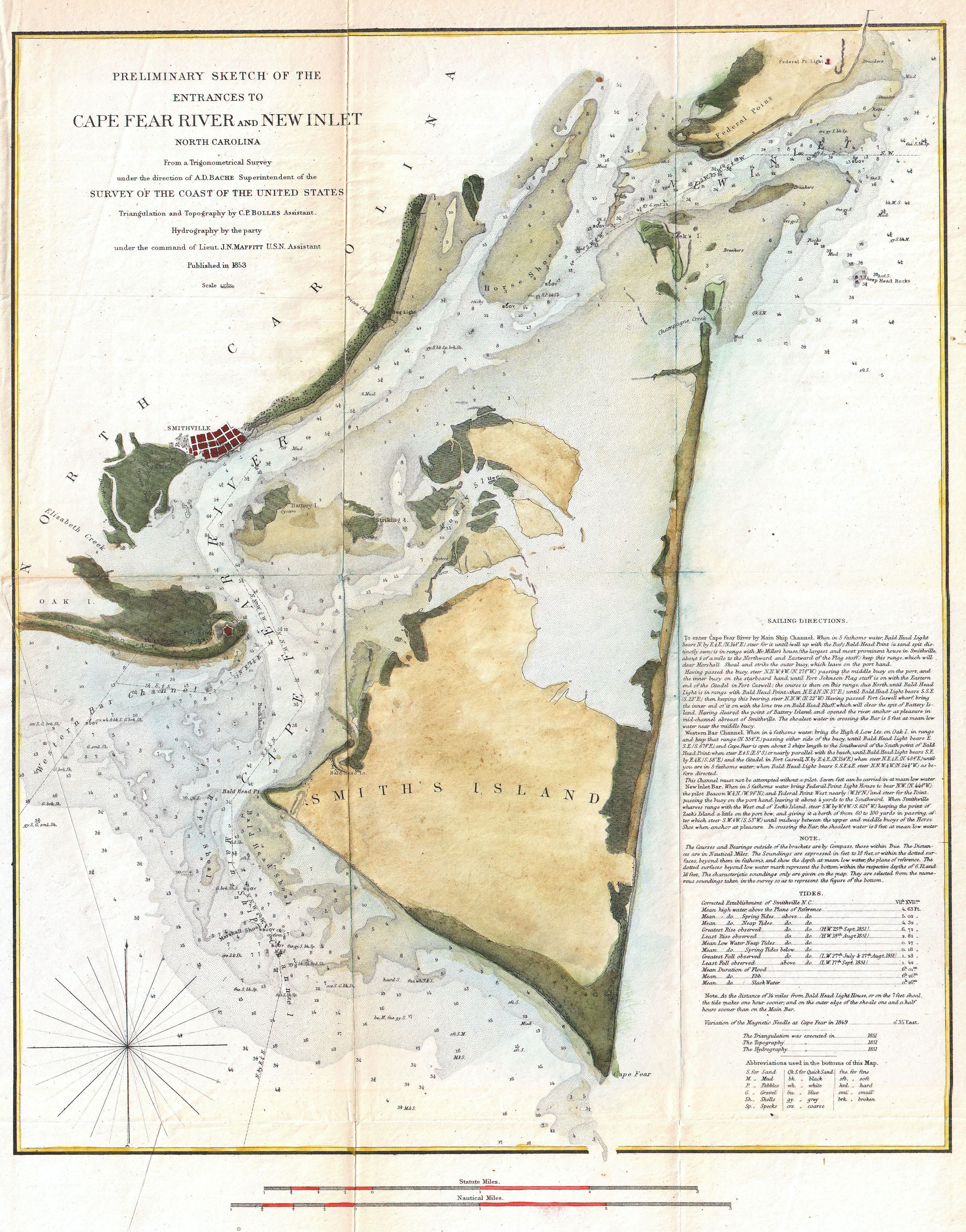
| Preliminary Chart of the Entrances to Cape Fear River and New Inlet North Carolina. | ||||||
|---|---|---|---|---|---|---|
| Artist | ||||||
| Title |
Preliminary Chart of the Entrances to Cape Fear River and New Inlet North Carolina. |
|||||
| Description |
English: One of the more striking examples of the U.S. Coast Survey Map of North Carolina’s Cape Fear and Cape Fear River. Extends from Federal Point south to the top of Cape Fear and then west past Smithville and Fort Caswell to Oak Island (roughly 78.04 Longitude). Offers superb coastal detail of the North Carolina mainland as well as Smith’s Island and Federal Point. From a nautical perspective the map offers a wealth of depths soundings and sailing instructions, as well as information on shoals, light houses, and tides. The triangulation for this chart was calculated by C. P. Bolles. The Hydrography was accomplished J. N. Maffitt. Prepared under the supervision of A. D. Bache for the 1853 Report of the Superintendant of the U.S. Coast Survey . |
|||||
| Date | 1853 (dated) | |||||
| Dimensions | height: 18 in (45.7 cm); width: 14 in (35.5 cm) | |||||
| Accession number |
Geographicus link: CapeFear2-uscs-1853 |
|||||
| Source/Photographer |
Report of the Superintendant of the U.S. Coast Survey, (1853 edition).
|
|||||
| Permission (Reusing this file) |
|
|||||
File history
Click on a date/time to view the file as it appeared at that time.
| Date/Time | Thumbnail | Dimensions | User | Comment | |
|---|---|---|---|---|---|
| current | 18:12, 22 March 2011 | | 3,918 × 5,000 (5.25 MB) | BotMultichillT | {{subst:User:Multichill/Geographicus |link=http://www.geographicus.com/P/AntiqueMap/CapeFear2-uscs-1853 |product_name=1853 U.S. Coast Survey Map of Cape Fear, North Carolina |map_title=Preliminary Chart of the Entrances to Cape Fear River and New Inlet No |
File usage
The following pages on the English Wikipedia use this file (pages on other projects are not listed):
Global file usage
The following other wikis use this file:
- Usage on www.wikidata.org