
Original file (1,280 × 960 pixels, file size: 2.3 MB, MIME type: image/jpeg)
| This is a file from the Wikimedia Commons. Information from its description page there is shown below. Commons is a freely licensed media file repository. You can help. |
Summary
| Description |
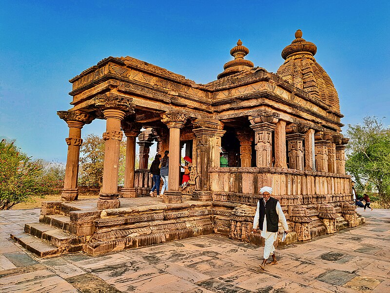
English: The Mahadeva temple, also known as Shiva temple of Nohta and Nohleshwar mandir, is a 10th-century Hindu temple near Nohta village, north of Jabalpur, Madhya Pradesh. It is notable as one of the best preserved Kalachuri-era Hindu temple masterpieces.
Nohta is now a small remote village. It was the capital of Kalachuri of Tripuri dynasty, also known as Kalchuris of Chedi. Nohta served as the capital before the 13th-century, and was a major city. When surveyed by Henry Cousens and other colonial era ASI archaeologists, Nohta had numerous ruins of Hindu and Jain temples, with mutilated artwork scattered over many square miles. Of these, the only standing temple and the most significant discovery was this Mahadeva temple. It is credited to a 10th century Chalukyan princess Nohala Devi who married a Kalchuri king, then likely brought the art influences and propelled a synthesis of Hindu art ideas from the Deccan region to those in Kalchuri-ruled central India. This Shiva temple stands on a large jagati (platform). It has a mukhamandapa, a sabhamandapa, an antarala and a garbhagriya. The temple has a Nagara style architecture with a pancharatha plan. The outer walls and two door frames are exquisitely decorated with Hindu art from Shaiva, Vaishnava, Shakta, Saura and Vedic traditions. Of particular note are the several panels for Lakshmi, Nataraja, and the relative rare and beautiful depiction of Bhadrakali as Vrishchika-dhari (goddess with scorpion on her belly). Vrishchikadhari form of the goddess is found in a few Hindu and a few Jain temples. She looks like Chamundi or Kali, but she isn't. She is uniquely identifiable from the scorpion on her belly. The Nohta Bhadrakali provides a key benchmark to compare her panels also found in temples of Khedbrahma (Gujarat), Un (Madhya Pradesh), Bhedaghat Yoginis (Madhya Pradesh), Belur (Karnataka), Ellora (Maharashtra), and the Bijolia Jain temple (Rajasthan). |
| Date | |
| Source | Own work |
| Author | Ms Sarah Welch |
| Camera location | | View this and other nearby images on: OpenStreetMap |
|---|
Licensing
| This file is made available under the Creative Commons CC0 1.0 Universal Public Domain Dedication. | |
| The person who associated a work with this deed has dedicated the work to the public domain by waiving all of their rights to the work worldwide under copyright law, including all related and neighboring rights, to the extent allowed by law. You can copy, modify, distribute and perform the work, even for commercial purposes, all without asking permission.
|
File history
Click on a date/time to view the file as it appeared at that time.
| Date/Time | Thumbnail | Dimensions | User | Comment | |
|---|---|---|---|---|---|
| current | 14:35, 20 February 2023 | | 1,280 × 960 (2.3 MB) | Ms Sarah Welch | Uploaded own work with UploadWizard |