
Size of this preview: 746 × 600 pixels. Other resolutions: 299 × 240 pixels | 597 × 480 pixels | 955 × 768 pixels | 1,273 × 1,024 pixels | 1,890 × 1,520 pixels.
Original file (1,890 × 1,520 pixels, file size: 852 KB, MIME type: image/jpeg)
| This is a file from the Wikimedia Commons. Information from its description page there is shown below. Commons is a freely licensed media file repository. You can help. |
Summary
| Artist |
|
||||||||||||||||||||||||||||||||||||||||||
| Title |
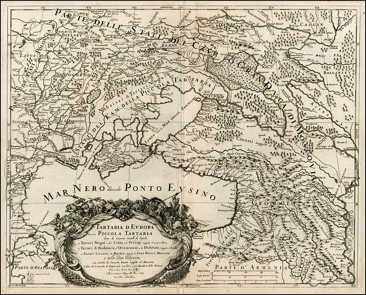
Italiano: Tartaria d Europa ouero Piccola Tartaria divisa da Giacomo Cantelli da Vignola ne Tartari Nogai e del Crim, o di Precop soggetti al proprio Kam ne Tartari di Budziack, d'Oczackow, e di Dobruss, soggetti al Turco ne Tartari Circassi, e de Mordua soggetti al Gran Duca di Moscovia e nelle Due Uckraine una abitata da Cosacchi Tanaiti soggetti al Moscovita l'altra de Cosacchi di Zaporowa ora liberi, e già dipendenti dalla Polonia. |
||||||||||||||||||||||||||||||||||||||||||
| Description |
Русский: Тартария Европы или Малая Тартария, разделённая Джакомо Кантелли да Виньола на Ногайских и Крымских татар, или Перекопских, подчинённых собственном ханам, татары Буджака, Очакова и Добруджа, подчиненных туркам, черкесских татары, и мордва, подчинённых Московскому Великому князю и две украйны, одна населённая Танаискими казаками, подвластными москвичам, а другая казаками Запорогой, ныне свободными и уже зависимыми от Польши.
Українська: Гравюра 1684 р. - карта південно-східної Європи, на міді. Карта вигравірувана Франциском Доріа. Картограф цієї мапи Джакомо Кантеллі (1643-1695).
English: Map of the Ukraine, Georgia, Moscovy, Southeastern Poland / Lithuania and the Black Sea, by Cantelli da Vignola and published in Rome by Rossi.
The map provides one of the most detailed and up to date treatments the area centered on the newly defined Ukraine, Black Sea and neighboring regions, with an ornate allegorical cartouche depicting the bloodly conflicts then being waged in the region. Français : La légende, dit en italien, Tartarie d'Europe ou Petite Tartarie divisée de Giacomo Cantelli da Vignola, en Tartarie Nogai et de Crimée, ou de Precop, sujette au Khan et Tartarie de Bidiack, d'Oczackow, et de Dobruss, sujet des Turques en Tartarie circassienne, et de Mordva, sujette du grand duché de Moscou et celui d'Ukraine, habitat des Cosaques Tanaiti sujets de Moscovie, les autres Cozaques de Zaporowa sont libres, et dependent déjà de la Pologne. |
||||||||||||||||||||||||||||||||||||||||||
| Date | 1684 | ||||||||||||||||||||||||||||||||||||||||||
| Medium | Uncolored | ||||||||||||||||||||||||||||||||||||||||||
| Dimensions | height: 18 cm (7 in); width: 22 cm (8.6 in) | ||||||||||||||||||||||||||||||||||||||||||
| Place of creation | Rome | ||||||||||||||||||||||||||||||||||||||||||
| Source/Photographer |
|
||||||||||||||||||||||||||||||||||||||||||
| Other versions |
|
||||||||||||||||||||||||||||||||||||||||||

.jpg)
| Annotations | This image is annotated: View the annotations at Commons |
Licensing
|
This is a faithful photographic reproduction of a two-dimensional, public domain work of art. The work of art itself is in the public domain for the following reason:
The official position taken by the Wikimedia Foundation is that "faithful reproductions of two-dimensional public domain works of art are public domain".
This photographic reproduction is therefore also considered to be in the public domain in the United States. In other jurisdictions, re-use of this content may be restricted; see Reuse of PD-Art photographs for details. | ||||
Original upload log
The original description page was here. All following user names refer to uk.wikipedia.
- 2012-03-13 17:34 Leonst 1276×1010× (1694559 bytes) {{Зображення |Назва= |Опис=Гравюра 1684 р. - карта південно-східної Європи, на міді. Карта вигравірувана Франциском Доріа. Картограф цієї мапи ...
File history
Click on a date/time to view the file as it appeared at that time.
| Date/Time | Thumbnail | Dimensions | User | Comment | |
|---|---|---|---|---|---|
| current | 15:22, 27 March 2012 | | 1,890 × 1,520 (852 KB) | Geagea | http://www.kolkhiberi.net/displayimage.php?album=11&pos=6 |
| 14:46, 27 March 2012 |  | 1,276 × 1,010 (1.62 MB) | File Upload Bot (Magnus Manske) | Transfered from uk.wikipedia by User:geagea using CommonsHelper |
File usage
The following 6 pages use this file:
Global file usage
The following other wikis use this file:
- Usage on ast.wikipedia.org
- Usage on de.wikipedia.org
- Usage on es.wikipedia.org
- Usage on et.wikipedia.org
- Usage on fa.wikipedia.org
- Usage on fr.wikipedia.org
- Usage on hr.wikipedia.org
- Usage on it.wikipedia.org
- Usage on kn.wikipedia.org
- Usage on pa.wikipedia.org
- Usage on ro.wikipedia.org
- Usage on ru.wikipedia.org
- Usage on sh.wikipedia.org
- Usage on sq.wikipedia.org
- Usage on tr.wikipedia.org
- Usage on tt.wikipedia.org
- Usage on uk.wikipedia.org