No higher resolution available.
ÖRF_2011.png (790 × 439 pixels, file size: 374 KB, MIME type: image/png)
| This is a file from the Wikimedia Commons. Information from its description page there is shown below. Commons is a freely licensed media file repository. You can help. |
Summary
| Description |
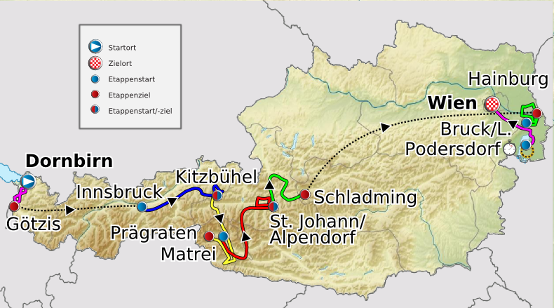
Deutsch: Verlauf der Österreich-Rundfahrt 2011
English: Route of the Tour of Austria 2011
Français : Parcours de la Tour d'Autriche 2011 |
| Date | 20 May 2011 (original upload date) |
| Source |
Transferred from de.wikipedia to Commons. |
| Author |
|
Licensing
I, the copyright holder of this work, hereby publish it under the following licenses:
This file is licensed under the Creative Commons Attribution-Share Alike 3.0 Unported license.
- You are free:
- to share – to copy, distribute and transmit the work
- to remix – to adapt the work
- Under the following conditions:
- attribution – You must give appropriate credit, provide a link to the license, and indicate if changes were made. You may do so in any reasonable manner, but not in any way that suggests the licensor endorses you or your use.
- share alike – If you remix, transform, or build upon the material, you must distribute your contributions under the same or compatible license as the original.

|
Permission is granted to copy, distribute and/or modify this document under the terms of the GNU Free Documentation License, Version 1.2 or any later version published by the Free Software Foundation; with no Invariant Sections, no Front-Cover Texts, and no Back-Cover Texts. A copy of the license is included in the section entitled GNU Free Documentation License. |
You may select the license of your choice.
Original upload log
The original description page was here. All following user names refer to de.wikipedia.
- 2011-05-23 17:12 Maxxl2 801×445× (397530 bytes) {{Information |Beschreibung = |Quelle = |Urheber = |Datum = |Genehmigung = |Andere Versionen = |Anmerkungen = Typo beseitigt }}
- 2011-05-23 12:51 Maxxl2 800×445× (397397 bytes) {{Information |Beschreibung = |Quelle = |Urheber = |Datum = |Genehmigung = |Andere Versionen = |Anmerkungen = Typo beseitigt - Auflösung verbessert }}
- 2011-05-20 21:05 Maxxl2 500×278× (180848 bytes) {{Information |Beschreibung = Verlauf der Österreich-Rundfahrt 2011 |Quelle = http://www.oesterreich-rundfahrt.at/ |Urheber = [[Maxxl2]] unter Verwendung der Karten von [[Lencer]] und [[Uwe Dedering]] |Datum = 20.05.2011
This image is a derivative work of the following images:
- File:Austria_location_map.svg licensed with Cc-by-sa-3.0, GFDL
- 2008-09-11T16:25:48Z Lencer 1256x700 (164515 Bytes) {{Information |Description= |Source= |Date= |Author= |Permission= |other_versions= }}
- 2008-09-10T15:16:19Z Lencer 1256x700 (161047 Bytes) {{Information |Description= |Source= |Date= |Author= |Permission= |other_versions= }}
- 2008-07-18T11:34:43Z NordNordWest 1256x700 (152529 Bytes) {{Information |Description= {{de|Positionskarte von [[:de:Österreich|Österreich]]}} Quadratische Plattkarte, N-S-Streckung 150 %. Geographische Begrenzung der Karte: * N: 49.2° N * S: 46.3° N * W: 9.4° O * O: 17.2
- File:Austria_relief_location_map.jpg licensed with Cc-by-sa-3.0, GFDL
- 2010-06-28T09:14:18Z Uwe Dedering 1256x700 (692901 Bytes) very little border change
- 2010-04-26T12:24:59Z Uwe Dedering 1256x700 (692757 Bytes) rhine
- 2010-04-24T12:54:54Z Uwe Dedering 1256x700 (692681 Bytes) {{Information |Description={{en|1=Location map of [[:en:Austria|Austria]]}} Equirectangular projection, N/S stretching 150 %. Geographic limits of the map: * N: 49.2° N * S: 46.3° N * W: 9.4° E * E: 17.2° E
Uploaded with derivativeFX
File history
Click on a date/time to view the file as it appeared at that time.
| Date/Time | Thumbnail | Dimensions | User | Comment | |
|---|---|---|---|---|---|
| current | 07:59, 8 July 2011 | | 790 × 439 (374 KB) | MaxxL | Reverted to version as of 07:57, 8 July 2011 |
| 07:58, 8 July 2011 |  | 790 × 439 (374 KB) | MaxxL | Reverted to version as of 21:14, 7 July 2011 | |
| 07:57, 8 July 2011 |  | 790 × 439 (374 KB) | MaxxL | second effort | |
| 21:14, 7 July 2011 |  | 790 × 439 (374 KB) | MaxxL | upgraded track | |
| 02:15, 29 May 2011 |  | 801 × 445 (388 KB) | Saibo | 2011-05-23 17:12 Maxxl2 801×445× (397530 bytes) Typo beseitigt | |
| 02:14, 29 May 2011 |  | 800 × 445 (388 KB) | Saibo | 2011-05-23 12:51 Maxxl2 800×445× (397397 bytes) Typo beseitigt - Auflösung verbessert | |
| 02:13, 29 May 2011 |  | 500 × 278 (177 KB) | Saibo | 2011-05-20 21:05 Maxxl2 500×278× (180848 bytes) ''<nowiki>{{Information |Beschreibung = Verlauf der Österreich-Rundfahrt 2011 |Quelle = http://www.oesterreich-rundfahrt.at/ |Urheber = Maxxl2 unter Verwend |
File usage
The following pages on the English Wikipedia use this file (pages on other projects are not listed):
Global file usage
The following other wikis use this file:
- Usage on de.wikipedia.org
- Usage on es.wikipedia.org
- Usage on fr.wikipedia.org
- Usage on pt.wikipedia.org
- Usage on ru.wikipedia.org
- Usage on uk.wikipedia.org