Elazığ Province (Turkish: Elazığ ili; Zazaki: Suke Xarpêt;[3] Kurdish: Parêzgeha Xarpêtê[4]) is a province of Turkey with its seat in the city of Elazığ. Its area is 9,383 km2,[5] and its population is 591,497 (2022).[2] The population of the province was 569,616 in 2000 and 498,225 in 1990. The province is considered part of Turkish Kurdistan and has a Kurdish majority[6][7] with a significant Turkish minority.
Elazığ Province
Elazığ ili | |
|---|---|
 İzzet Pasha Mosque in the city centre | |
 Location of the province within Turkey | |
| Country | Turkey |
| Seat | Elazığ |
| Government | |
| • Governor | Ömer Toraman[1] |
| Area | 9,383 km2 (3,623 sq mi) |
| Population (2022)[2] | 591,497 |
| • Density | 63/km2 (160/sq mi) |
| Time zone | UTC+3 (TRT) |
| Area code | 0424 |
| Website | www |
History
editIn 1927 the office of the Inspector General was created, which governed with martial law.[8] The province was included in the first Inspectorate General (Umumi Müfettişlik, UM) over which the Inspector General ruled. The UM span over the provinces of Hakkâri, Siirt, Van, Mardin, Bitlis, Şanlıurfa, Elazığ and Diyarbakır.[9]
In December 1935, the Tunceli Law was passed, which demanded a more powerful Government in the region.[10] In January 1936 the Elazığ Province was transferred under the authority of the newly established Fourth Inspectorate General, which span over the provinces of Elazığ, Erzincan, Bingöl and Tunceli[11] and its seat was in the city of Elazığ.[12] The fourth UM was governed by a Governor-Commander. Most of the employees in the municipalities had to be from the military and the Governor-Commander had the authority to evacuate whole villages and resettle them in another part of the province.[13] In 1946 the Tunceli Law was abolished and the state of emergency removed but the authority of the fourth UM was transferred to the military.[13]
The Inspectorates General were dissolved in 1952 during the Government of the Democrat Party.[14]
The province has experienced many earthquakes, including a magnitude 6.1 earthquake on 8 March 2010 and a magnitude 6.7 earthquake on 24 January 2020.[15]
Geography
editElazığ stretches in a general west-southwest to east-northeast direction, along the line of equal geographic latitude and longitude. The source of the Euphrates river is located in this province. 826 km2 (319 sq mi) of its area is covered by reservoirs and natural lakes.[16][17]
Districts
edit
Elazığ province is divided into 11 districts (capital district in bold):
Economy
editHistorically, Elazığ Province produced silver, which ceased being mined in 1885. The Turkish government attempted to modernize the mines; however, the cost of fuel and energy caused the shut down. There was a silver mine still producing in 1903 in Palu, as with coal. Coal is also found in other areas of the province. Gold and salt was also produced.[18]
Education
editEducation is provided by the Elazığ Provincial Directorate for National Education. It currently views over 442 educational institutions, both formal and informal ones.[19]
Archaeology
editAltınova, Elazığ was an important archaeological site in the Altınova plain that was excavated in the 1970s. It was later flooded by the Keban Dam. Other sites in the Altınova plain were also Tepecik, Korucutepe, Değirmentepe, and Körtepe.
Gallery
edit-
 Elazığ Train Station
 -
 Palu and the Murat river
 -
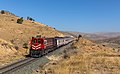 DE 24 184 of TCDD (Türkiye Cumhuriyeti Devlet Demiryollari) at Pınarlı, Turkey.
 -
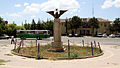
 Culture Park
 -

-
 City view at night
 -
 Doğukent Stadium
 -
 Stone Bridge, Palu


See also
editReferences
edit- ^ "Elazığ Valisi Dr. Omer TORAMAN". www.elazig.gov.tr. Archived from the original on 2021-10-07. Retrieved 25 October 2023.
- ^ a b "Address-based population registration system (ADNKS) results dated 31 December 2022, Favorite Reports" (XLS). TÜİK. Retrieved 19 September 2023.
- ^ Zazaca -Türkçe Sözlük, R. Hayıg-B. Werner
- ^ "Li Wanê taxek hat kerentînekirin" (in Kurdish). Rûdaw. 8 April 2020. Retrieved 27 April 2020.
- ^ "İl ve İlçe Yüz ölçümleri". General Directorate of Mapping. Retrieved 19 September 2023.
- ^ "Kurds, Kurdistān". Encyclopaedia of Islam (2 ed.). BRILL. 2002. ISBN 9789004161214.
- ^ Gunes, Cengiz (2020-11-26). The Political Representation of Kurds in Turkey: New Actors and Modes of Participation in a Changing Society. Bloomsbury Publishing. ISBN 978-0-7556-0634-4.
- ^ Jongerden, Joost (1 January 2007). The Settlement Issue in Turkey and the Kurds: An Analysis of Spatical Policies, Modernity and War. BRILL. p. 53. ISBN 978-90-04-15557-2.
- ^ Bayir, Derya (2016-04-22). Minorities and Nationalism in Turkish Law. Routledge. p. 139. ISBN 978-1-317-09579-8.
- ^ Cagaptay, Soner (2 May 2006). Islam, Secularism and Nationalism in Modern Turkey: Who is a Turk?. Routledge. pp. 108–110. ISBN 978-1-134-17448-5.
- ^ Cagaptay (2006), p.110
- ^ Soner Çaǧaptay, Islam, Secularism, and Nationalism in Modern Turkey: Who is a Turk?, Taylor & Francis, 2006, ISBN 978-0-415-38458-2, p. 48
- ^ a b Bayir, Derya (2016-04-22). Minorities and Nationalism in Turkish Law. Routledge. pp. 139–141. ISBN 978-1-317-09579-8.
- ^ Fleet, Kate; Kunt, I. Metin; Kasaba, Reşat; Faroqhi, Suraiya (2008-04-17). The Cambridge History of Turkey. Cambridge University Press. p. 343. ISBN 978-0-521-62096-3.
- ^ "M 6.7 - 13km N of Doganyol, Turkey". earthquake.usgs.gov. Retrieved 2020-04-01.
- ^ "Elazığ Province". Encyclopaedia of Islam (2 ed.). BRILL: 167. 2002. ISBN 9789004161214.
- ^ Mutlu, Servet (1996). "Ethnic Kurds in Turkey: A Demographic Study". International Journal of Middle East Studies. 28 (4): 526. doi:10.1017/S0020743800063819. ISSN 0020-7438. JSTOR 176151. S2CID 154212694 – via JSTOR.
- ^ Prothero, W.G. (1920). Armenia and Kurdistan. London: H.M. Stationery Office. p. 74.
- ^ Solmaz, Remzi (2015-12-14). "Elazig City Department Of Education". EPALE - European Commission. Retrieved 2020-05-23.
External links
edit- (in Turkish) Elazığ governor's official website
- (in Turkish) Elazığ municipality's official website
- (in English) Elazığ weather forecast information