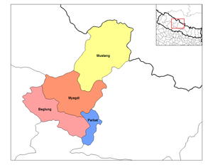
Dhaulagiri (Nepali: धौलागिरी अञ्चल ) was one of the fourteen zones which Nepal was divided into for administrative purposes, prior to the September 10, 2015 adoption of a new Constitution, which divided the nation instead into 7 provinces. It is in the Western Development Region of Nepal and its headquarters are Baglung. Famous trekking areas like Mustang, Muktinath, Kali Gandaki valley and Mt Dhaulagiri fall in this zone. Dhorpatan Hunting Reserve, the only hunting reserve in Nepal is spread over Baglung and Myagdi Districts of this zone.
Dhaulagiri Zone
धौलागिरी अञ्चल | |
|---|---|
 Dhaulagiri Zone | |
| Country | |
| Area | |
| • Total | 8,148 km2 (3,146 sq mi) |
| Population (2001) | |
| • Total | 556,191 |
| • Density | 68/km2 (180/sq mi) |
| Time zone | UTC+5:45 (Nepal Time) |
Administrative subdivisions
editDhaulagiri was divided into four districts; since 2015 these districts have been redesignated as part of Gandaki Province.
| District | Type | Headquarters | Since 2015 part of Province |
|---|---|---|---|
| Baglung | Hill | Baglung | Gandaki Province |
| Mustang | Mountain | Jomsom | |
| Myagdi | Hill | Beni | |
| Parbat | Hill | Kusma |
The Dhaulagiri circuit in Eastern Rukum encompasses the Dhaulagiri mountain range of the northern Lumbini Province. The Dhaulagiri mountain range extends from the northwest to the northeast of Eastern Rukum district and then continues eastward to its tallest peak at Dhaulagiri I. Putha Hiunchuli (Dhaulagiri VII), one of the most popular 7,000-metre mountains, was first climbed by British explorer J. O. M. Roberts and Sherpa Ang Nyima in 1954.[1]
The West Dhaulagiri circuit is a tourist trekking circuit close to the Dhaulagiri mountain range and Magar-majority villages, with a distinct preserved Kham Magar culture of the northern Lumbini province.The circuit's eastern portion is situated along the Dhorpatan reserve of Eastern Rukum, which was designated to preserve high-altitude ecosystems in western Nepal in 1983.[2] The reserve harbours alpine, sub-alpine and high temperate vegetation and 137 species of birds. Endangered animals in the reserve include the musk deer, wolf, red panda, cheer pheasant and danphe.
See also
edit- Development Regions of Nepal (Former)
- List of zones of Nepal (Former)
- List of districts of Nepal