Cucalón is a municipality located in the province of Teruel, Aragon, Spain. According to the 2010 census the municipality has a population of 102 inhabitants.[2] This town gives its name to the Sierra de Cucalón system of mountain ranges.
Cucalón | |
|---|---|
 Flag .svg) Coat of arms | |
 Cucalón | |
| Coordinates: 41°5′N 1°13′W / 41.083°N 1.217°W | |
| Country | Spain |
| Autonomous community | Aragon |
| Province | Teruel |
| Comarca | Jiloca |
| Area | |
| • Total | 31.87 km2 (12.31 sq mi) |
| Elevation | 1,036 m (3,399 ft) |
| Population (2018)[1] | |
| • Total | 80 |
| Time zone | UTC+1 (CET) |
| • Summer (DST) | UTC+2 (CEST) |
There are ruins of an ancient Iberian settlement, known as Peña el Castillo, located within Cucalón's municipal term.[3]
Gallery
edit-
 Street in Cucalón with the remains of Santiago church
 -
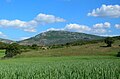 La Modorra, highest point in the Sierra de Cucalón system


See also
editReferences
edit- ^ Municipal Register of Spain 2018. National Statistics Institute.
- ^ Instituto Nacional de Estadística (Spain)
- ^ "GEA - Huerva, valle de la". Archived from the original on 2012-03-13. Retrieved 2011-05-14.
External links
editWikimedia Commons has media related to Cucalón.
- Cucalón, Jiloca[permanent dead link]
- Cucalón
- Sierra de Cucalón
- Guía general de las sierras de Cucalón, Oriche y Fonfría
This article about a location in the Province of Teruel is a stub. You can help Wikipedia by expanding it. |